Approximate Location Map
Large Map »
Latitude: 51.4768 / 51°28'36"N
Longitude: -1.6207 / 1°37'14"W
OS Eastings: 426436
OS Northings: 175386
OS Grid: SU264753
Mapcode National: GBR 5XY.C20
Mapcode Global: VHC1J.V4KP
Plus Code: 9C3WF9GH+PP
Entry Name: 5, the Butts
Listing Date: 9 September 1977
Grade: II
Source: Historic England
Source ID: 1034177
English Heritage Legacy ID: 310464
ID on this website: 101034177
Location: Aldbourne, Wiltshire, SN8
County: Wiltshire
Civil Parish: Aldbourne
Built-Up Area: Aldbourne
Traditional County: Wiltshire
Lieutenancy Area (Ceremonial County): Wiltshire
Tagged with: Building Thatched cottage
SU 27 NE ALDBOURNE THE BUTTS
(west side)
9/4 No 5
9.9.77
GV II
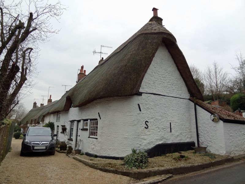
2 cottages in row, now one house. C17-C18. Chalk, flint and sarsen
rubble, rendered at right end, and thatched roof. 3-bay, 1 storey
and attic. C20 rear lean-to. C20 boarded door. 9-pane sashes to
ground floor with timber lintels and timber casement windows over.
Thatch swept over flush dormers and drawn down over right gable
with rounded end.
Interior has spine beams.
Listing NGR: SU2643675386
External links are from the relevant listing authority and, where applicable, Wikidata. Wikidata IDs may be related buildings as well as this specific building. If you want to add or update a link, you will need to do so by editing the Wikidata entry.


Other nearby listed buildings
