Approximate Location Map
Large Map »
Latitude: 51.4796 / 51°28'46"N
Longitude: -1.6206 / 1°37'14"W
OS Eastings: 426441
OS Northings: 175693
OS Grid: SU264756
Mapcode National: GBR 5XY.537
Mapcode Global: VHC1J.V2LL
Plus Code: 9C3WF9HH+RP
Entry Name: Red Cottage
Listing Date: 22 August 1966
Grade: II
Source: Historic England
Source ID: 1283225
English Heritage Legacy ID: 310490
ID on this website: 101283225
Location: Aldbourne, Wiltshire, SN8
County: Wiltshire
Civil Parish: Aldbourne
Built-Up Area: Aldbourne
Traditional County: Wiltshire
Lieutenancy Area (Ceremonial County): Wiltshire
Tagged with: Cottage
SU 27 NE ALDBOURNE THE GREEN
(west side)
9/30 No 2 (Red Cottage)
22.8.66
GV II
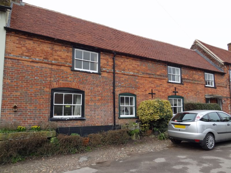
House, C18. Flemish brickwork, tiled roof. 2-storey, 4 bays 1 room
deep. Entrance in 2nd bay now removed to right end bay c1960
panelled, with side lights and canopy. 6-pane sash windows with
segmental heads. Plat band cut by lowered first floor windows.
Brick dentilled eaves relating to lowering of the roof in C19.
Stack at left end. Forecourt of sarsen cobbles.
Listing NGR: SU2643975683
External links are from the relevant listing authority and, where applicable, Wikidata. Wikidata IDs may be related buildings as well as this specific building. If you want to add or update a link, you will need to do so by editing the Wikidata entry.


Other nearby listed buildings
