Approximate Location Map
Large Map »
Latitude: 51.4807 / 51°28'50"N
Longitude: -1.6181 / 1°37'5"W
OS Eastings: 426614
OS Northings: 175816
OS Grid: SU266758
Mapcode National: GBR 5XY.5PG
Mapcode Global: VHC1J.W1XR
Plus Code: 9C3WF9JJ+7P
Entry Name: 3 Oxford Street
Listing Date: 6 March 1985
Grade: II
Source: Historic England
Source ID: 1034158
English Heritage Legacy ID: 310515
ID on this website: 101034158
Location: Aldbourne, Wiltshire, SN8
County: Wiltshire
Civil Parish: Aldbourne
Built-Up Area: Aldbourne
Traditional County: Wiltshire
Lieutenancy Area (Ceremonial County): Wiltshire
Tagged with: Building
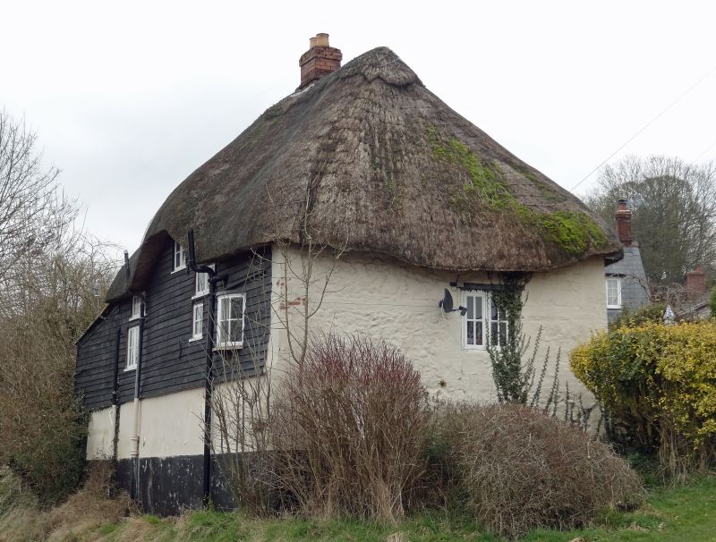
ALDBOURNE OXFORD STREET (north west side)
SU 27 NE 9/55
No 3
II
Cottage, C17-C18 on steep slope over Lottage Road. Colourwash over part timber framing, with brick laced sarsen infill, weatherboarded to rear. Thatched roof. 1-storey and attic, 2 bays with left lean-to extension. C20 glazed door opposite central stack and 4-pane casement windows. Thatch hipped both ends and swept over 2 flush dormers to front, one to rear. Interior with chamfered spine beams.
Listing NGR: SU2661475816
External links are from the relevant listing authority and, where applicable, Wikidata. Wikidata IDs may be related buildings as well as this specific building. If you want to add or update a link, you will need to do so by editing the Wikidata entry.


Other nearby listed buildings
