Approximate Location Map
Large Map »
Latitude: 51.4785 / 51°28'42"N
Longitude: -1.6188 / 1°37'7"W
OS Eastings: 426571
OS Northings: 175571
OS Grid: SU265755
Mapcode National: GBR 5XY.CJS
Mapcode Global: VHC1J.W3LF
Plus Code: 9C3WF9HJ+9F
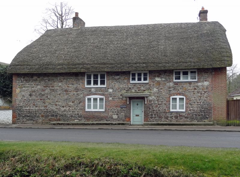
Entry Name: Glebe House
Listing Date: 22 August 1966
Grade: II
Source: Historic England
Source ID: 1034163
English Heritage Legacy ID: 310528
ID on this website: 101034163
Location: Aldbourne, Wiltshire, SN8
County: Wiltshire
Civil Parish: Aldbourne
Built-Up Area: Aldbourne
Traditional County: Wiltshire
Lieutenancy Area (Ceremonial County): Wiltshire
Tagged with: House
ALDBOURNE SOUTH STREET (west side)
SU 27 NE 9/68
No 6 (Glebe House)
22.8.66
GV II
House, C18-C19. Sarsen rubble with brick dressings and brick gable to right. Thatched roof. 2-storey, 4 bays, the first bay blind. 3-panelled door central to 3 remaining bays under C20 supported canopy. C19 timber casement windows with segmental heads on ground floor. Roof hipped left and stack in first bay, and stack right in rebuilt gable. Interior: inglenook in right bay.
Listing NGR: SU2657175571
External links are from the relevant listing authority and, where applicable, Wikidata. Wikidata IDs may be related buildings as well as this specific building. If you want to add or update a link, you will need to do so by editing the Wikidata entry.


Other nearby listed buildings
