Approximate Location Map
Large Map »
Latitude: 51.4312 / 51°25'52"N
Longitude: -1.5368 / 1°32'12"W
OS Eastings: 432299
OS Northings: 170345
OS Grid: SU322703
Mapcode National: GBR 6ZZ.88W
Mapcode Global: VHC1S.99X5
Plus Code: 9C3WCFJ7+F7
Entry Name: Mill Cottage
Listing Date: 6 March 1985
Grade: II
Source: Historic England
Source ID: 1034147
English Heritage Legacy ID: 310592
ID on this website: 101034147
Location: Chilton Foliat, Wiltshire, RG17
County: Wiltshire
Civil Parish: Chilton Foliat
Built-Up Area: Chilton Foliat
Traditional County: Wiltshire
Lieutenancy Area (Ceremonial County): Wiltshire
Tagged with: Cottage Thatched cottage
SU 37 SW CHILTON FOLIAT A.419
(north side)
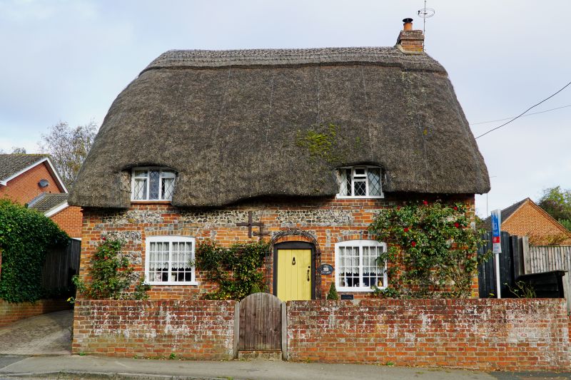
5/129 Mill cottage
II
Cottage. C19. Banded brick and flint with thatched roof.
Weatherboarded gables. 1-storey and attic. 2 bays. Boarded door
in centre. 2-light iron casements with segmental brick heads to
ground floor, 3-light diamond leaded to 2 flush dormers. Stack in
right gable.
Listing NGR: SU3229970345
External links are from the relevant listing authority and, where applicable, Wikidata. Wikidata IDs may be related buildings as well as this specific building. If you want to add or update a link, you will need to do so by editing the Wikidata entry.


Other nearby listed buildings
