Approximate Location Map
Large Map »
Latitude: 51.4425 / 51°26'33"N
Longitude: -1.6054 / 1°36'19"W
OS Eastings: 427524
OS Northings: 171576
OS Grid: SU275715
Mapcode National: GBR 5YC.GY5
Mapcode Global: VHC1R.405H
Plus Code: 9C3WC9VV+2V
Entry Name: 4, High Street
Listing Date: 6 March 1985
Grade: II
Source: Historic England
Source ID: 1365475
English Heritage Legacy ID: 310662
ID on this website: 101365475
Location: Ramsbury, Wiltshire, SN8
County: Wiltshire
Civil Parish: Ramsbury
Built-Up Area: Ramsey
Traditional County: Wiltshire
Lieutenancy Area (Ceremonial County): Wiltshire
Tagged with: Building
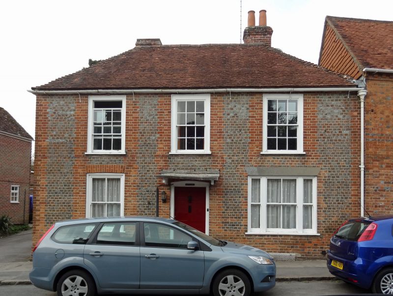
SU 27 SE RAMSBURY HIGH STREET
(north side)
10/204 No 4
II
House, later C18 - early C19. Vitrified brick with red brick quoins
and dressings. Banded plain tile roof. 2-storey, 3 bays. Central
door to hall and flanking reception rooms, 2 rooms deep. 4-panel
door with simple canopy. 12-pane sashes with flush boxes, replaced
with 4-pane on ground floor, the right bay being tripartite.
Hipped roof and rear stacks.
Listing NGR: SU2752471579
External links are from the relevant listing authority and, where applicable, Wikidata. Wikidata IDs may be related buildings as well as this specific building. If you want to add or update a link, you will need to do so by editing the Wikidata entry.


Other nearby listed buildings
