Approximate Location Map
Large Map »
Latitude: 51.3436 / 51°20'37"N
Longitude: -1.6333 / 1°37'59"W
OS Eastings: 425637
OS Northings: 160569
OS Grid: SU256605
Mapcode National: GBR 5ZH.MX2
Mapcode Global: VHC23.MHXB
Plus Code: 9C3W89V8+FM
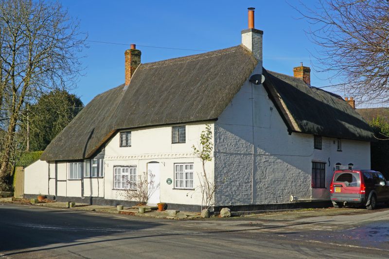
Entry Name: The Olde Shoppe
Listing Date: 30 July 1986
Grade: II
Source: Historic England
Source ID: 1183675
English Heritage Legacy ID: 310759
ID on this website: 101183675
Location: East Grafton, Wiltshire, SN8
County: Wiltshire
Civil Parish: Grafton
Built-Up Area: East Grafton
Traditional County: Wiltshire
Lieutenancy Area (Ceremonial County): Wiltshire
Tagged with: Architectural structure Thatched cottage
GRAFTON THE GREEN, East Grafton
SU 26 SE
(north side)
5/39 The Olde Shoppe
II
Cottage. C18 - C19. Brick with timber framed extension left, and
thatched roof. Two-storey, 2 bays. Central boarded door and
timber casement windows, leaded to first floor. Three course brick
string course. Left extension of single storey mixed framing and
windows. Rear 1 bay wring with further lean-to along Dark Lane.
Listing NGR: SU2563760569
External links are from the relevant listing authority and, where applicable, Wikidata. Wikidata IDs may be related buildings as well as this specific building. If you want to add or update a link, you will need to do so by editing the Wikidata entry.


Other nearby listed buildings
