Approximate Location Map
Large Map »
Latitude: 51.352 / 51°21'7"N
Longitude: -1.6151 / 1°36'54"W
OS Eastings: 426901
OS Northings: 161509
OS Grid: SU269615
Mapcode National: GBR 5ZJ.0JB
Mapcode Global: VHC23.Y8JW
Plus Code: 9C3W992M+RX
Entry Name: Manor Farmhouse
Listing Date: 30 July 1986
Grade: II
Source: Historic England
Source ID: 1365487
English Heritage Legacy ID: 310785
ID on this website: 101365487
Location: Wilton, Wiltshire, SN8
County: Wiltshire
Civil Parish: Grafton
Traditional County: Wiltshire
Lieutenancy Area (Ceremonial County): Wiltshire
Tagged with: Farmhouse Thatched farmhouse
GRAFTON WILTON (east side)
SU 26 SE 5/63
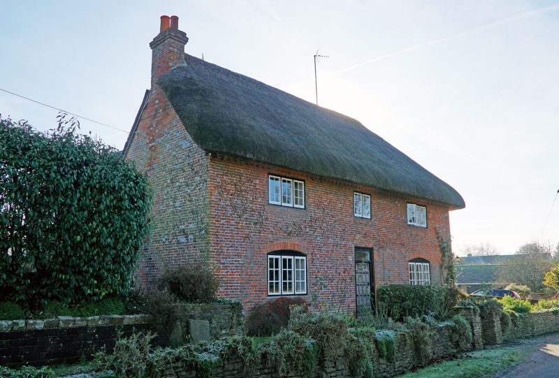
Manor Farmhouse
II
Farmhouse, C17 - C18. Brick with thatched roof. Two-storey, 3 bays with 3-bay rear wing on right, and C19 wing with slate roof on left. Central C20 panelled door. Three-light paned casement windows with segmental heads. Roof hipped to right. Brick stack to left gable and between right wing and right bay. Brick dentilled eaves. Building incorporates at rear timber framed cottage gable to road. Interior: some timber framing.
Listing NGR: SU2690161509
External links are from the relevant listing authority and, where applicable, Wikidata. Wikidata IDs may be related buildings as well as this specific building. If you want to add or update a link, you will need to do so by editing the Wikidata entry.


Other nearby listed buildings
