Approximate Location Map
Large Map »
Latitude: 51.2368 / 51°14'12"N
Longitude: -1.7901 / 1°47'24"W
OS Eastings: 414749
OS Northings: 148646
OS Grid: SU147486
Mapcode National: GBR 4Z9.J6M
Mapcode Global: VHB54.X5HP
Plus Code: 9C3W66P5+PX
Entry Name: The Yews
Listing Date: 3 June 1986
Grade: II
Source: Historic England
Source ID: 1365530
English Heritage Legacy ID: 311056
ID on this website: 101365530
Location: Netheravon, Wiltshire, SP4
County: Wiltshire
Civil Parish: Netheravon
Built-Up Area: Netheravon
Traditional County: Wiltshire
Lieutenancy Area (Ceremonial County): Wiltshire
Church of England Parish: Netheravon All Saints
Church of England Diocese: Salisbury
Tagged with: Architectural structure
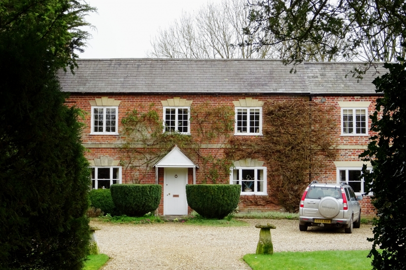
NETHERAVON HIGH STREET
SU 14 NW (east side)
9/108 The Yews
II
House. Late C18. Brick with slate roof. Two storeys, 3 bays.
Central stair hall. C20 door in gabled lattice porch, C19
tripartite sashes to ground floor, casements to first floor, both
with C18 stone lintels with stepped keystones. Stone plat band.
Gable stacks. Shutters removed for decoration at time of
inspection.
Listing NGR: SU1474948646
External links are from the relevant listing authority and, where applicable, Wikidata. Wikidata IDs may be related buildings as well as this specific building. If you want to add or update a link, you will need to do so by editing the Wikidata entry.


Other nearby listed buildings
