Approximate Location Map
Large Map »
Latitude: 51.3679 / 51°22'4"N
Longitude: -2.0358 / 2°2'8"W
OS Eastings: 397602
OS Northings: 163206
OS Grid: ST976632
Mapcode National: GBR 2TS.249
Mapcode Global: VHB47.NWL7
Plus Code: 9C3V9X97+5M
Entry Name: Rowdeford Bridge
Listing Date: 3 April 1987
Grade: II
Source: Historic England
Source ID: 1033883
English Heritage Legacy ID: 311168
ID on this website: 101033883
Location: Rowde, Wiltshire, SN10
County: Wiltshire
Civil Parish: Rowde
Traditional County: Wiltshire
Lieutenancy Area (Ceremonial County): Wiltshire
Tagged with: Bridge
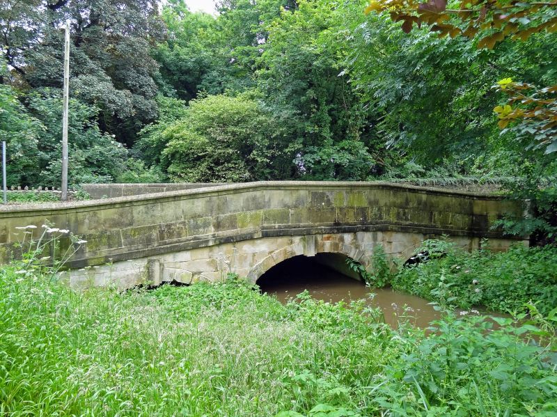
ST 96 SE BROMHAM DEVIZES ROAD
4/18 Rowdeford Bridge
II
Road bridge over Summerham brook, dated 1771, repaired and widened
1815, ashlar. Three shallow arches with triple keystones, raised
band and plain parapet, altered on east side. West parapet is
dated 1771 on road side and 1815 on river side. The bridge spans
the boundary to Bromham parish.
Listing NGR: ST9760263206
External links are from the relevant listing authority and, where applicable, Wikidata. Wikidata IDs may be related buildings as well as this specific building. If you want to add or update a link, you will need to do so by editing the Wikidata entry.


Other nearby listed buildings
