Approximate Location Map
Large Map »
Latitude: 51.497 / 51°29'49"N
Longitude: -1.82 / 1°49'11"W
OS Eastings: 412594
OS Northings: 177579
OS Grid: SU125775
Mapcode National: GBR 4W5.2PB
Mapcode Global: VHB3S.DMQR
Plus Code: 9C3WF5WJ+R2
Entry Name: Garden Wall at Uffcott Farm
Listing Date: 2 September 1986
Grade: II
Source: Historic England
Source ID: 1284677
English Heritage Legacy ID: 311276
ID on this website: 101284677
Location: Uffcott, Wiltshire, SN4
County: Wiltshire
Civil Parish: Broad Hinton
Traditional County: Wiltshire
Lieutenancy Area (Ceremonial County): Wiltshire
Tagged with: Wall
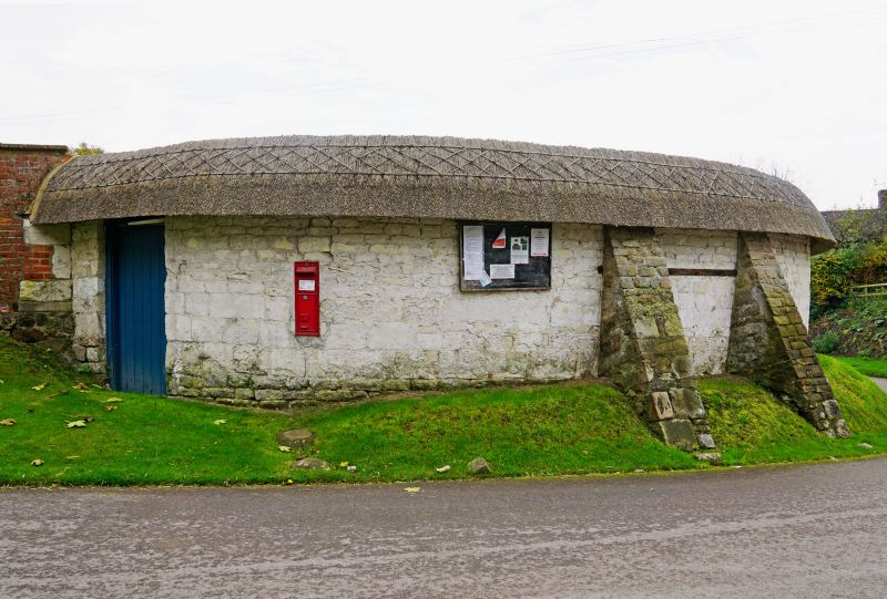
SU 17 NW BROAD HINTON UFFCOTT
2/32 Garden wall at Uffcott Farm
II
Garden wall. C18-C19. Squared chalkstone with thatched coping.
Wall forms 'U' on plan with rounded end against road containing C19
wall post-box. Two later sarsen raking buttresses. Soffite
board supported on transverse timber plates through top courses of
wall. Door to garden. Inner face has series of brick boxes in
top section, either bee boles or for frost fires.
Listing NGR: SU1259477579
External links are from the relevant listing authority and, where applicable, Wikidata. Wikidata IDs may be related buildings as well as this specific building. If you want to add or update a link, you will need to do so by editing the Wikidata entry.


Other nearby listed buildings
