Approximate Location Map
Large Map »
Latitude: 51.2859 / 51°17'9"N
Longitude: -1.9789 / 1°58'44"W
OS Eastings: 401566
OS Northings: 154090
OS Grid: SU015540
Mapcode National: GBR 2VT.BJ1
Mapcode Global: VHB4N.NY52
Plus Code: 9C3W72PC+9C
Entry Name: The Malthouse
Listing Date: 25 March 1988
Grade: II
Source: Historic England
Source ID: 1182830
English Heritage Legacy ID: 312082
ID on this website: 101182830
Location: Market Lavington, Wiltshire, SN10
County: Wiltshire
Civil Parish: Market Lavington
Built-Up Area: Market Lavington
Traditional County: Wiltshire
Lieutenancy Area (Ceremonial County): Wiltshire
Tagged with: Architectural structure
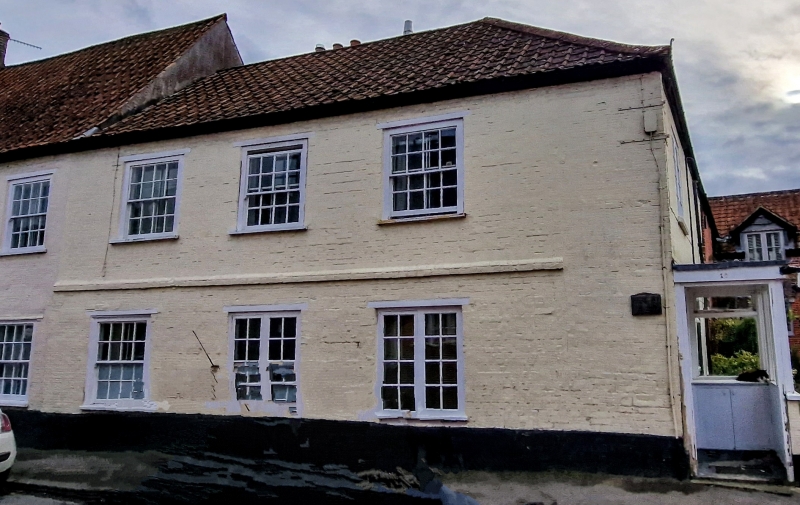
MARKET LAVINGTON WHITE STREET
SU 0054-0154
(west side)
12/176 No 10 (The Malthouse)
GV II
House. C18. Colourwashed brick with pantiled roof. Two storeys,
3 bays. Entrance at right side. Sixteen-paned sashes with timber
lintels, two replaced on ground floor. Roof hipped to right.
Included primarily for group value.
Listing NGR: SU0161254026
External links are from the relevant listing authority and, where applicable, Wikidata. Wikidata IDs may be related buildings as well as this specific building. If you want to add or update a link, you will need to do so by editing the Wikidata entry.


Other nearby listed buildings
