Approximate Location Map
Large Map »
Latitude: 51.3132 / 51°18'47"N
Longitude: -1.9482 / 1°56'53"W
OS Eastings: 403703
OS Northings: 157121
OS Grid: SU037571
Mapcode National: GBR 3WT.L7T
Mapcode Global: VHB4P.58W4
Plus Code: 9C3W8372+7P
Entry Name: Oakfrith Cottage
Listing Date: 5 July 1977
Grade: II
Source: Historic England
Source ID: 1364615
English Heritage Legacy ID: 312117
ID on this website: 101364615
Location: Cuckoo's Corner, Wiltshire, SN10
County: Wiltshire
Civil Parish: Urchfont
Built-Up Area: Urchfont
Traditional County: Wiltshire
Lieutenancy Area (Ceremonial County): Wiltshire
Tagged with: Cottage
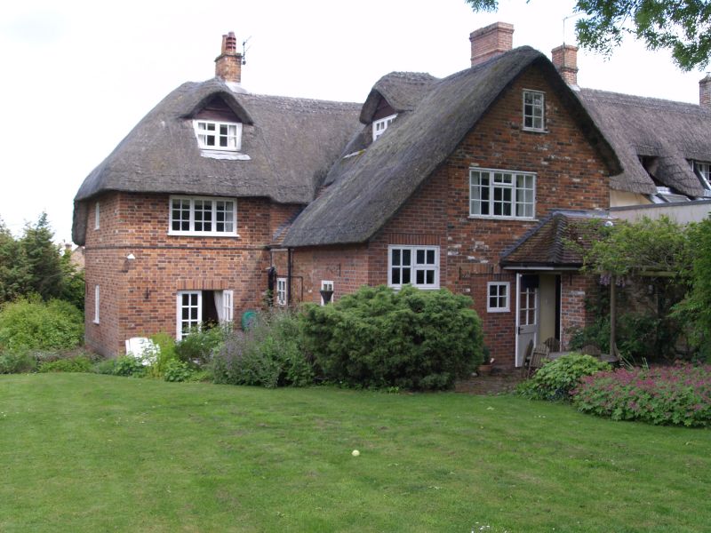
URCHFONT THE GREEN
SU 0357
(west side)
10/211 Oakfrith Cottage
5.7.77
GV II
Cottage end of row. Late C17 or C18. Flemish brickwork on stone
footings, thatched roof. Two storeys and attic, 3 bays, with
fourth single storey bay added to right. Central half-glazed door
in heavy frame. Reset floating moulded brick dentilled pediment,
and copied over door to extension. Early C20 casement windows,
those on ground floor with segmental arches. Plat band. Sun
Fire mark No. 685654.
Listing NGR: SU0370357121
External links are from the relevant listing authority and, where applicable, Wikidata. Wikidata IDs may be related buildings as well as this specific building. If you want to add or update a link, you will need to do so by editing the Wikidata entry.


Other nearby listed buildings
