Approximate Location Map
Large Map »
Latitude: 51.3135 / 51°18'48"N
Longitude: -1.948 / 1°56'52"W
OS Eastings: 403717
OS Northings: 157156
OS Grid: SU037571
Mapcode National: GBR 3WT.L9X
Mapcode Global: VHB4P.670X
Plus Code: 9C3W8372+CQ
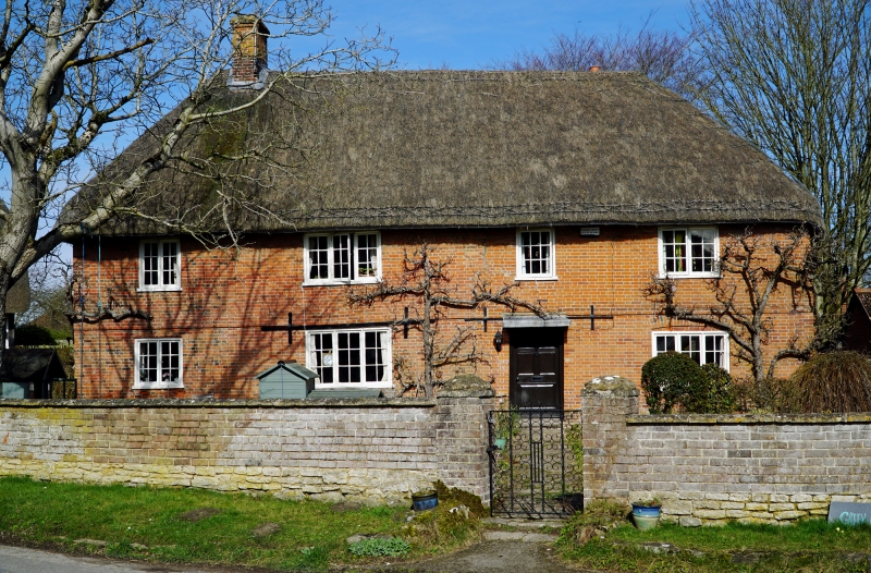
Entry Name: Green Farmhouse
Listing Date: 25 March 1988
Grade: II
Source: Historic England
Source ID: 1035868
English Heritage Legacy ID: 312119
ID on this website: 101035868
Location: Cuckoo's Corner, Wiltshire, SN10
County: Wiltshire
Civil Parish: Urchfont
Built-Up Area: Urchfont
Traditional County: Wiltshire
Lieutenancy Area (Ceremonial County): Wiltshire
Tagged with: Farmhouse Thatched farmhouse
URCHFONT THE GREEN
SU 0357
(north side)
10/213 Green Farmhouse
GV II
Farmhouse. C17. refaced in C18. Timber framed with Flemish
brick facade and thatched roof. Two storeys, four bays. Five
panelled door in third bay with flat canopy. Paned casement
windows. Brick stringcourse. Stack between bays 1 and 2. Roof
hipped. Framing 4 panels high with corner braces. Single storey
1 bay thatched wing to rear of left bay. Interior not seen, may
be of interest.
Listing NGR: SU0371757156
External links are from the relevant listing authority and, where applicable, Wikidata. Wikidata IDs may be related buildings as well as this specific building. If you want to add or update a link, you will need to do so by editing the Wikidata entry.


Other nearby listed buildings
