Approximate Location Map
Large Map »
Latitude: 51.3142 / 51°18'51"N
Longitude: -1.9431 / 1°56'35"W
OS Eastings: 404059
OS Northings: 157233
OS Grid: SU040572
Mapcode National: GBR 3WT.FKB
Mapcode Global: VHB4P.87LC
Plus Code: 9C3W8374+MP
Entry Name: Gate Piers to Manor Farm, and Mounting Block
Listing Date: 25 March 1988
Grade: II
Source: Historic England
Source ID: 1035871
English Heritage Legacy ID: 312128
ID on this website: 101035871
Location: Urchfont, Wiltshire, SN10
County: Wiltshire
Civil Parish: Urchfont
Built-Up Area: Urchfont
Traditional County: Wiltshire
Lieutenancy Area (Ceremonial County): Wiltshire
Tagged with: Gatepost
URCHFONT HIGH STREET
SU 0457
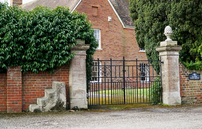
11/222 Gate piers to Manor Farm,
and mounting block
GV II
Gate piers and mounting block west of Manor Farmhouse. C18.
Ashlar limestone with chamfered corners, necking and moulded caps.
Pineapple stone finials. On left, a monolithic limestone mounting
block of four steps.
Listing NGR: SU0405957231
External links are from the relevant listing authority and, where applicable, Wikidata. Wikidata IDs may be related buildings as well as this specific building. If you want to add or update a link, you will need to do so by editing the Wikidata entry.


Other nearby listed buildings
