Approximate Location Map
Large Map »
Latitude: 51.2616 / 51°15'41"N
Longitude: -1.6088 / 1°36'31"W
OS Eastings: 427392
OS Northings: 151454
OS Grid: SU273514
Mapcode National: GBR 60H.VF8
Mapcode Global: VHC2J.2KB6
Plus Code: 9C3W796R+JF
Entry Name: Farm Building South of Crawlboys Farmhouse
Listing Date: 13 June 1988
Grade: II
Source: Historic England
Source ID: 1036000
English Heritage Legacy ID: 312446
ID on this website: 101036000
Location: Wiltshire, SP11
County: Wiltshire
Civil Parish: Ludgershall
Traditional County: Wiltshire
Lieutenancy Area (Ceremonial County): Wiltshire
Tagged with: Agricultural structure
LUDGERSHALL CRAWLBOYS LANE
SU 25 SE
(north side)
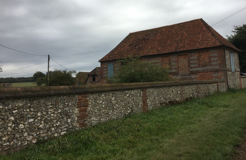
9/115 Farm building south of
Crawlboys Farmhouse
GV II
Farm building. Early-mid C18. Brick laced flint with tiled roof.
Two storeys, 6 bays, comprising stables on ground floor and stores
above. Various openings to both floors, with gauged brick lintels
to lower floor. Plat band. Half brick lintels to upper floor.
Roof hipped.
Listing NGR: SU2739251454
External links are from the relevant listing authority and, where applicable, Wikidata. Wikidata IDs may be related buildings as well as this specific building. If you want to add or update a link, you will need to do so by editing the Wikidata entry.


Other nearby listed buildings
