Approximate Location Map
Large Map »
Latitude: 51.2055 / 51°12'19"N
Longitude: -2.1829 / 2°10'58"W
OS Eastings: 387319
OS Northings: 145154
OS Grid: ST873451
Mapcode National: GBR 1V6.6YF
Mapcode Global: VH97H.3YVS
Plus Code: 9C3V6R48+5R
Entry Name: The Chantry
Listing Date: 28 April 1952
Last Amended: 31 March 1978
Grade: II*
Source: Historic England
Source ID: 1036217
English Heritage Legacy ID: 312929
ID on this website: 101036217
Location: Warminster, Wiltshire, BA12
County: Wiltshire
Civil Parish: Warminster
Built-Up Area: Warminster
Traditional County: Wiltshire
Lieutenancy Area (Ceremonial County): Wiltshire
Church of England Parish: Warminster St Denys
Church of England Diocese: Salisbury
Tagged with: Architectural structure
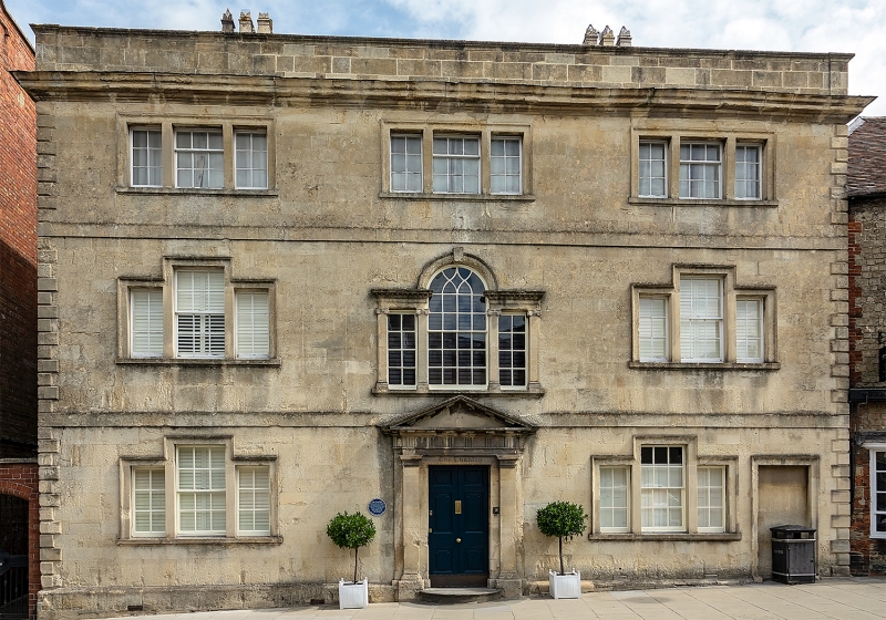
WARMINSTER HIGH STREET
1.
5411
(North Side)
No 34 (The Chantry)
[Formerly listed as
No 24 (The Chantry)]
ST 8745 SW 6/25 28.4.52.
II* GV
2.
Circa 1750-60. Possibly by a Longleat estate surveyor/architect. 3 storeys.
Recently cleaned Bath stone. Projecting plinth with moulded coping, plain
bands at each floor. Small rusticated quoins. Moulded cornice. Plain parapet
with moulded coping and old tile roof. Glazing bar sash windows with stone
architrave surrounds. Three 3 light windows on 1st floor, with centre light
4 panes high and side lights 3 panes high, (rectangular variation of a venetian
window). 2 similar windows under, on ground floor flanking 6 panel central
door in Doric surround, of pilasters, triglyph frieze, moulded and bracketed
cornice with pediment and with Palladian window over on mezzanine level, with
Ionic pilasters framing lights and carrying bolection frieze and moulded and
bracketted cornices. Architrave round arch of central light has interlacing
"Gothic" glazing pattern. The right hand ground floor window is out of alignment
with windows over to allow for secondary entrance in right hand corner now
blocked. Early C19 rear extension to north-east with 2 large windows per
floor. Interior: fine contemporary oak staircase with 1st floor and landing
galleries, ramped sills and panelled dados, 2 balusters per tread. Oak (?)
interior joinery to central Ionic Palladian window. Dentil cornice to main
hall which has diamond pattern flagged floor. This building is not unlike
Byne House (church Street) and Dilton Vale Farmhouse (Westbury).
Listing NGR: ST8731945154
External links are from the relevant listing authority and, where applicable, Wikidata. Wikidata IDs may be related buildings as well as this specific building. If you want to add or update a link, you will need to do so by editing the Wikidata entry.


Other nearby listed buildings
