Approximate Location Map
Large Map »
Latitude: 51.3337 / 51°20'1"N
Longitude: -2.2102 / 2°12'36"W
OS Eastings: 385455
OS Northings: 159418
OS Grid: ST854594
Mapcode National: GBR 1SM.61V
Mapcode Global: VH96W.MQYZ
Plus Code: 9C3V8QMQ+FW
Entry Name: Aqueduct over River Biss
Listing Date: 26 November 1976
Grade: II
Source: Historic England
Source ID: 1364207
English Heritage Legacy ID: 314077
ID on this website: 101364207
Location: Wiltshire, BA14
County: Wiltshire
Civil Parish: Trowbridge
Built-Up Area: Trowbridge
Traditional County: Wiltshire
Lieutenancy Area (Ceremonial County): Wiltshire
Church of England Parish: Staverton with Hilperton Marsh
Church of England Diocese: Salisbury
Tagged with: Aqueduct
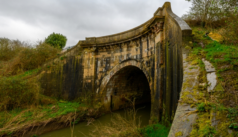
KENNET AND AVON CANAL
1.
5411
Aqueduct over river Biss
ST 85 NE 3/305
II
2.
Early Cl9 ashlar. Curved retaining walls. High above river: single arch flanked
by piers. Wide modillion cornice to curving parapet with moulded cope.
Listing NGR: ST8545559418
External links are from the relevant listing authority and, where applicable, Wikidata. Wikidata IDs may be related buildings as well as this specific building. If you want to add or update a link, you will need to do so by editing the Wikidata entry.


Other nearby listed buildings
