Approximate Location Map
Large Map »
Latitude: 51.321 / 51°19'15"N
Longitude: -2.2117 / 2°12'42"W
OS Eastings: 385343
OS Northings: 158004
OS Grid: ST853580
Mapcode National: GBR 1SS.5NF
Mapcode Global: VH972.M235
Plus Code: 9C3V8QCQ+98
Entry Name: Town Bridge
Listing Date: 29 December 1950
Grade: II
Source: Historic England
Source ID: 1364191
English Heritage Legacy ID: 314192
ID on this website: 101364191
Location: Trowbridge, Wiltshire, BA14
County: Wiltshire
Civil Parish: Trowbridge
Built-Up Area: Trowbridge
Traditional County: Wiltshire
Lieutenancy Area (Ceremonial County): Wiltshire
Church of England Parish: Trowbridge St James
Church of England Diocese: Salisbury
Tagged with: Bridge
WICKER HILL
1.
5411
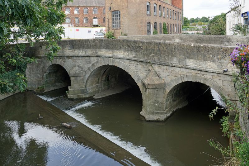
Town Bridge
ST 8557 4/85
ST 8558 6/85 29.12.50.
II
2.
Built by local architect Esau Reynolds, 1777 (cf incised stone in central of parapet
to south east). Restored and widened; over River Biss. 3 segmental arches, central
larger. To south east, 2 pointed breakwaters, raised band below parapet. To north
west chamfered rusticated surrounds and keystones.
Listing NGR: ST8534358004
External links are from the relevant listing authority and, where applicable, Wikidata. Wikidata IDs may be related buildings as well as this specific building. If you want to add or update a link, you will need to do so by editing the Wikidata entry.


Other nearby listed buildings
