Approximate Location Map
Large Map »
Latitude: 51.4923 / 51°29'32"N
Longitude: -2.2289 / 2°13'44"W
OS Eastings: 384203
OS Northings: 177064
OS Grid: ST842770
Mapcode National: GBR 1QN.79V
Mapcode Global: VH963.BR0C
Plus Code: 9C3VFQRC+WC
Entry Name: The Bridge
Listing Date: 20 December 1960
Last Amended: 9 December 1985
Grade: II
Source: Historic England
Source ID: 1022879
English Heritage Legacy ID: 317245
ID on this website: 101022879
Location: Castle Combe, Wiltshire, SN14
County: Wiltshire
Civil Parish: Castle Combe
Traditional County: Wiltshire
Lieutenancy Area (Ceremonial County): Wiltshire
Church of England Parish: Castle Combe
Church of England Diocese: Bristol
Tagged with: Bridge
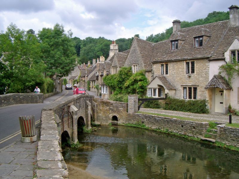
CASTLE COMBE THE STREET
ST 8477
6/155 The Bridge
20.12.60 (formerly listed as Bridge over
By Brook 15 yds south of Post
Office
GV II
Bridge, early C19, rubble stone with 3 low segmental skew arches
and coped parapets. Against east side are 4 shallow ashlar
buttresses grooved to hold iron screens against livestock. Centre
screen missing.
Listing NGR: ST8420377064
External links are from the relevant listing authority and, where applicable, Wikidata. Wikidata IDs may be related buildings as well as this specific building. If you want to add or update a link, you will need to do so by editing the Wikidata entry.


Other nearby listed buildings
