Approximate Location Map
Large Map »
Latitude: 51.6373 / 51°38'14"N
Longitude: -1.8579 / 1°51'28"W
OS Eastings: 409927
OS Northings: 193172
OS Grid: SU099931
Mapcode National: GBR 3S1.C2T
Mapcode Global: VHB35.R34P
Plus Code: 9C3WJ4PR+WR
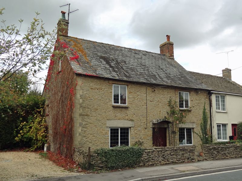
Entry Name: Malt House
Listing Date: 26 August 1976
Last Amended: 17 April 1986
Grade: II
Source: Historic England
Source ID: 1182927
English Heritage Legacy ID: 317759
ID on this website: 101182927
Location: Cricklade, Wiltshire, SN6
County: Wiltshire
Civil Parish: Cricklade
Built-Up Area: Cricklade
Traditional County: Wiltshire
Lieutenancy Area (Ceremonial County): Wiltshire
Church of England Parish: Cricklade
Church of England Diocese: Bristol
Tagged with: House Malt house
SU 09 SE CRICKLADE THE FORTY
(west side)
12/110 No. 8 (Malt House)
(formerly listed as No 8)
26.8.76
II
House, dated 1837. Limestone rubble to front. Dressed quoins and
quoins to openings. Stone slate roof. Two storeys, 2 bays.
Central boarded door. Two-light false leaded casements to first
floor, 3-light to ground floor. Gable lit attic. Datestone under
eaves.
Listing NGR: SU0992793172
External links are from the relevant listing authority and, where applicable, Wikidata. Wikidata IDs may be related buildings as well as this specific building. If you want to add or update a link, you will need to do so by editing the Wikidata entry.


Other nearby listed buildings
