Approximate Location Map
Large Map »
Latitude: 51.6427 / 51°38'33"N
Longitude: -1.8554 / 1°51'19"W
OS Eastings: 410101
OS Northings: 193780
OS Grid: SU101937
Mapcode National: GBR 3RV.ZPP
Mapcode Global: VHB2Z.SZH2
Plus Code: 9C3WJ4VV+3R
Entry Name: 52, High Street
Listing Date: 26 August 1976
Grade: II
Source: Historic England
Source ID: 1356064
English Heritage Legacy ID: 317790
ID on this website: 101356064
Location: Cricklade, Wiltshire, SN6
County: Wiltshire
Civil Parish: Cricklade
Built-Up Area: Cricklade
Traditional County: Wiltshire
Lieutenancy Area (Ceremonial County): Wiltshire
Church of England Parish: Cricklade
Church of England Diocese: Bristol
Tagged with: Building
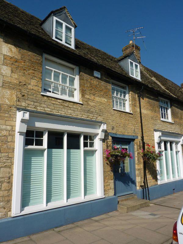
SU 19 SW CRICKLADE HIGH STREET
(west side)
13/140 No. 52
26.8.76
GV
II
Two shops in terrace, C17 or C18. Coursed limestone rubble, stone
slate roof. Two storeys, 2 bays. Ground floor has 2 early C20
shop windows flanking off-centre doorway with wooden lintel.
Twelve-pane sashes to first floor, widely spaced. Right gable
stack.
Listing NGR: SU1009993780
External links are from the relevant listing authority and, where applicable, Wikidata. Wikidata IDs may be related buildings as well as this specific building. If you want to add or update a link, you will need to do so by editing the Wikidata entry.


Other nearby listed buildings
