Approximate Location Map
Large Map »
Latitude: 51.6445 / 51°38'40"N
Longitude: -1.8549 / 1°51'17"W
OS Eastings: 410139
OS Northings: 193973
OS Grid: SU101939
Mapcode National: GBR 3RV.ZV7
Mapcode Global: VHB2Z.SXSQ
Plus Code: 9C3WJ4VW+Q3
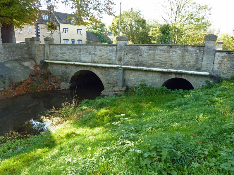
Entry Name: Town Bridge
Listing Date: 26 August 1976
Grade: II
Source: Historic England
Source ID: 1023113
English Heritage Legacy ID: 317807
ID on this website: 101023113
Location: Cricklade, Wiltshire, SN6
County: Wiltshire
Civil Parish: Cricklade
Built-Up Area: Cricklade
Traditional County: Wiltshire
Lieutenancy Area (Ceremonial County): Wiltshire
Church of England Parish: Cricklade
Church of England Diocese: Bristol
Tagged with: Arch bridge Road bridge Stone bridge
SU 19 SW CRICKLADE HIGH STREET
13/157 Town Bridge
II
Bridge over River Thames. 1854. Limestone with rubble parapet and
end piers. Single arch to Thames and smaller side arch on north
for former mill leet. Panels to both east and west sides recording
the rebuilding of the bridge by the Feoffees of the Wayland Estate,
1854.
Listing NGR: SU1013993973
External links are from the relevant listing authority and, where applicable, Wikidata. Wikidata IDs may be related buildings as well as this specific building. If you want to add or update a link, you will need to do so by editing the Wikidata entry.


Other nearby listed buildings
