Approximate Location Map
Large Map »
Latitude: 51.5838 / 51°35'1"N
Longitude: -1.863 / 1°51'46"W
OS Eastings: 409591
OS Northings: 187228
OS Grid: SU095872
Mapcode National: GBR 3SM.PTM
Mapcode Global: VHB3C.NGH5
Plus Code: 9C3WH4MP+GR
Entry Name: Garnary and Dovecote at Manor House
Listing Date: 17 April 1986
Grade: II
Source: Historic England
Source ID: 1198315
English Heritage Legacy ID: 317949
ID on this website: 101198315
Location: Church End, Wiltshire, SN5
County: Wiltshire
Civil Parish: Purton
Traditional County: Wiltshire
Lieutenancy Area (Ceremonial County): Wiltshire
Church of England Parish: Purton
Church of England Diocese: Bristol
Tagged with: Dovecote
SU 08 NE
8/301
PURTON
CHURCH END
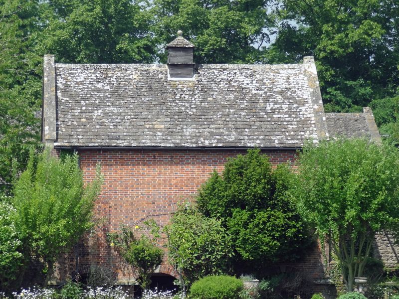
Granary and Dovecote at the Manor House
GV
II
Granary with dovecote over. 1746. Diaper brickwork with stone
slate roof between raised parapets. Building raised on 16 brick
piers with capstones and segmental stone keyed brick arches.
Various small openings. Stone copings and gabled apex stone.
Datestone in gable and timber glover.
Listing NGR: SU0959187228
External links are from the relevant listing authority and, where applicable, Wikidata. Wikidata IDs may be related buildings as well as this specific building. If you want to add or update a link, you will need to do so by editing the Wikidata entry.


Other nearby listed buildings
