Approximate Location Map
Large Map »
Latitude: 51.5506 / 51°33'1"N
Longitude: -1.6519 / 1°39'6"W
OS Eastings: 424230
OS Northings: 183575
OS Grid: SU242835
Mapcode National: GBR 5WY.P6C
Mapcode Global: VHC14.B916
Plus Code: 9C3WH82X+66
Entry Name: Manor Farmhouse
Listing Date: 20 September 1979
Grade: II
Source: Historic England
Source ID: 1184025
English Heritage Legacy ID: 318203
ID on this website: 101184025
Location: Bishopstone, Swindon, Wiltshire, SN6
County: Swindon
Civil Parish: Bishopstone
Built-Up Area: Bishopstone
Traditional County: Wiltshire
Lieutenancy Area (Ceremonial County): Wiltshire
Church of England Parish: Bishopstone with Hinton Parva
Church of England Diocese: Bristol
Tagged with: Farmhouse Thatched farmhouse
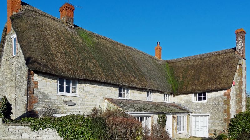
1.
5410 BISHOPSTONE HINTON ROAD
Bishopstone
Manor Farmhouse
SU 2483 28/5
II
2.
C18, altered early-mid C19 by 'L' extension to east front and remodelling.
Later brick extension to north. Two storeys and attic thatched house with 3
brick chimneys. Chalk rubble occasionally coursed and dressed and in varying thicknesees
Brick quoins.
West front: later brick and slate extension to left, 3 windows on first floor,
casements, altered and irregular ground floor windows, modern glazed porch to
centre and modern box porch to right. Two dormers cut into thatch.
East front: 'L' plan 4 windows and one to projecting wing on first floor, mostly
3-light casements. Later large tiled lean-to across most of ground floor with
wide 3-light glazing bar casements flanking door. Gable end of 'L' wing has
large external chimney with brick quoins. Said to have datestone marked 1770.
Mid C19 curved chalk corner wall to east - coursed and dressed rubble, tiled
capping, about 3 ft high to west rising to 7 ft to north, about 19 yds. Also
tile capped sarsen wall facing road to south-west: about 25 yds and 6 ft high,
links to similar wall of chalk rubble about 8 yds long.
Listing NGR: SU2423083575
External links are from the relevant listing authority and, where applicable, Wikidata. Wikidata IDs may be related buildings as well as this specific building. If you want to add or update a link, you will need to do so by editing the Wikidata entry.


Other nearby listed buildings
