Approximate Location Map
Large Map »
Latitude: 51.6305 / 51°37'49"N
Longitude: -1.7106 / 1°42'38"W
OS Eastings: 420125
OS Northings: 192446
OS Grid: SU201924
Mapcode National: GBR 4TL.LBP
Mapcode Global: VHC0Q.98JX
Plus Code: 9C3WJ7JQ+5P
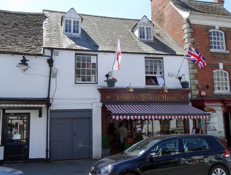
Entry Name: 16, High Street
Listing Date: 26 January 1955
Grade: II
Source: Historic England
Source ID: 1184827
English Heritage Legacy ID: 318396
ID on this website: 101184827
Location: Highworth, Swindon, Wiltshire, SN6
County: Swindon
Civil Parish: Highworth
Built-Up Area: Highworth
Traditional County: Wiltshire
Lieutenancy Area (Ceremonial County): Wiltshire
Church of England Parish: Highworth with Sevenhampton and Inglesham
Church of England Diocese: Bristol
Tagged with: Building
1.
5410 HIGHWORTH HIGH STREET
(south side)
No 16
SU 2092 SW 18/277 26.1.55
II GV
2.
Late C18 stucco faced. Slate roof. Two storeys and dormers. Two windows,
glazing bar sashes. Modern shop front. Through passage to left with arched
entry.
Listing NGR: SU2012892437
External links are from the relevant listing authority and, where applicable, Wikidata. Wikidata IDs may be related buildings as well as this specific building. If you want to add or update a link, you will need to do so by editing the Wikidata entry.


Other nearby listed buildings
