Approximate Location Map
Large Map »
Latitude: 51.5857 / 51°35'8"N
Longitude: -1.7202 / 1°43'12"W
OS Eastings: 419483
OS Northings: 187460
OS Grid: SU194874
Mapcode National: GBR 4V4.HX7
Mapcode Global: VHC0X.4DGS
Plus Code: 9C3WH7PH+7W
Entry Name: The Red House
Listing Date: 20 September 1979
Grade: II
Source: Historic England
Source ID: 1023405
English Heritage Legacy ID: 318527
ID on this website: 101023405
Location: South Marston, Swindon, Wiltshire, SN3
County: Swindon
Civil Parish: South Marston
Traditional County: Wiltshire
Lieutenancy Area (Ceremonial County): Wiltshire
Church of England Parish: Stratton St Margaret with South Marston
Church of England Diocese: Bristol
Tagged with: House
1.
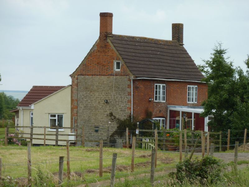
5410 SOUTH MARSTON SOUTH MARSTON
The Red House
SU 18 NE 8/415
II
2.
Early C19. Two storeys and gable lit attic. Rubble with red brick front
with brick block eaves cornice. Brick quoins. Two ranges of 3 light casements
and central modern gabled porch. Stone tile roof with gable end brick chimneys.
Listing NGR: SU1948387460
External links are from the relevant listing authority and, where applicable, Wikidata. Wikidata IDs may be related buildings as well as this specific building. If you want to add or update a link, you will need to do so by editing the Wikidata entry.


Other nearby listed buildings
