Approximate Location Map
Large Map »
Latitude: 51.0687 / 51°4'7"N
Longitude: -1.7977 / 1°47'51"W
OS Eastings: 414270
OS Northings: 129954
OS Grid: SU142299
Mapcode National: GBR 517.VQS
Mapcode Global: FRA 7639.CGY
Plus Code: 9C3W3692+FW
Entry Name: 12 12A and 14, Bridge Street
Listing Date: 12 October 1972
Grade: II
Source: Historic England
Source ID: 1023546
English Heritage Legacy ID: 318874
ID on this website: 101023546
Location: Salisbury, Wiltshire, SP1
County: Wiltshire
Civil Parish: Salisbury
Built-Up Area: Salisbury
Traditional County: Wiltshire
Lieutenancy Area (Ceremonial County): Wiltshire
Church of England Parish: Salisbury St Thomas and St Edmund
Church of England Diocese: Salisbury
Tagged with: Building
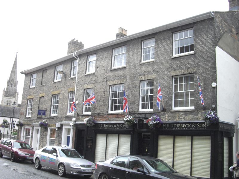
BRIDGE STREET
1.
1594
(North Side)
Nos 12, 12A and 14
SU 1429 NW 3/391
II GV
2.
Circa 1830-40 block formerly of 4 houses. 3 storeys grey brick. Low pitch
gable end slate roof with flat and moulded bracketed eaves. 8 windows to upper
floors, one blind, recessed sashes, glazing bars intact. Nos 12 and 12A modern
shop fronts. No 14 on ground floor has a wide segmented arched tripartite
sash, no glazing bars, a blocked doorway and a single sash to right. Remaining
house entrances have panelled doors with rectangular fanlights, No 12 has
panelled reveals, reeded architrave cases with rounded corner blocks, shallow
cornices. No 14 has a return front facing river, to west: the gable end has
a stone moulding to form an open pediment. 2 windows, recessed sashes second
floor, first floor has tripartite segmented arched sash to right. On ground
floor a rectangular bay with panelled surround to lights. To left in wing
superimposed canted bays, some glazing bars. Lower 2 storey rendered wing
extending along bank 3 windows and canted bay cantilevered over water.
Nos 12, 12A and 14 form a group with the Salisbury Generating Station,
St Thomas's Square.
Listing NGR: SU1427029954
External links are from the relevant listing authority and, where applicable, Wikidata. Wikidata IDs may be related buildings as well as this specific building. If you want to add or update a link, you will need to do so by editing the Wikidata entry.


Other nearby listed buildings
