Approximate Location Map
Large Map »
Latitude: 51.0706 / 51°4'14"N
Longitude: -1.7966 / 1°47'47"W
OS Eastings: 414344
OS Northings: 130158
OS Grid: SU143301
Mapcode National: GBR 517.W05
Mapcode Global: FRA 7639.5W9
Plus Code: 9C3W36C3+68
Entry Name: 27, 29 and 29A, Castle Street
Listing Date: 12 October 1972
Grade: II
Source: Historic England
Source ID: 1355859
English Heritage Legacy ID: 318897
ID on this website: 101355859
Location: Salisbury, Wiltshire, SP1
County: Wiltshire
Civil Parish: Salisbury
Built-Up Area: Salisbury
Traditional County: Wiltshire
Lieutenancy Area (Ceremonial County): Wiltshire
Church of England Parish: Salisbury St Thomas and St Edmund
Church of England Diocese: Salisbury
Tagged with: Building
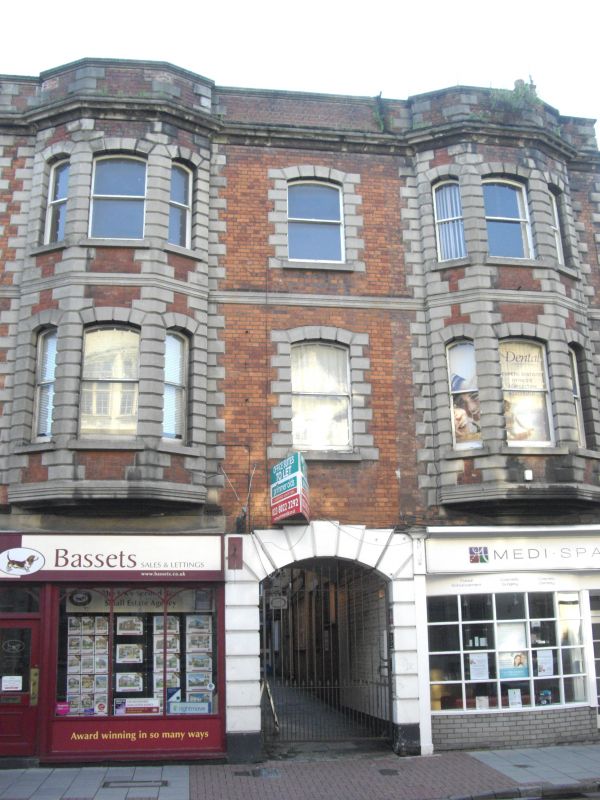
CASTLE STREET
1.
1594 (West Side)
Nos 27, 29, 29A
(including premises to rear
of No 29A at west end of yard)
SU 1430 SW 1/402
II GV
2.
Mid to later C19. 3 storeys red brick symmetrical front. Heavy rusticated
stone quoins, carved up into parapet with moulded coping. Moulded string
between storeys and heavy moulded cornice. The upper floors have central
window and flanking superimposed brick bays also with heavily rusticated quoins,
the cornice and parapet breaking forward over, and with moulded stepped bases
at 1st floor level. Sash windows segment headed, centre windows wider, no
glazing bars. Central archway with rusticated surround on ground floor.
Altered modernised shop fronts either side. To the rear of No 27 is a 3 storey
timber framed tile hung wing C17 or early C18, with jettied 2nd floor. Hipped
old tile roof. To the rear of the yard adjoining the wing of No 29A at right
angles is a former warehouse, mid C17. Queen post roof with butt purlins
and plain wind braces.
Nos 27 to 35 (odd) form a group.
Listing NGR: SU1434430158
External links are from the relevant listing authority and, where applicable, Wikidata. Wikidata IDs may be related buildings as well as this specific building. If you want to add or update a link, you will need to do so by editing the Wikidata entry.


Other nearby listed buildings
