Approximate Location Map
Large Map »
Latitude: 51.0662 / 51°3'58"N
Longitude: -1.7954 / 1°47'43"W
OS Eastings: 414435
OS Northings: 129671
OS Grid: SU144296
Mapcode National: GBR 51F.2WW
Mapcode Global: FRA 7649.DDS
Plus Code: 9C3W3683+FV
Entry Name: Theological College
Listing Date: 28 February 1952
Grade: I
Source: Historic England
Source ID: 1023595
English Heritage Legacy ID: 318988
Also known as: Salisbury Theological College
Salisbury & Wells Theological College
ID on this website: 101023595
Location: The Friary, Wiltshire, SP1
County: Wiltshire
Civil Parish: Salisbury
Built-Up Area: Salisbury
Traditional County: Wiltshire
Lieutenancy Area (Ceremonial County): Wiltshire
Tagged with: College Charitable organisation
THE CLOSE
1.
1594 No 19
(Theological College)
SU 1429 NW 3/42 28.2.52.
I GV
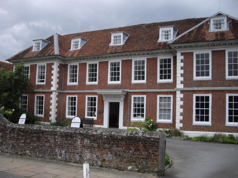
2.
Late C17. 2 storey and attic. A symmetrical front with flanking slightly
projecting wings. Brick on stone capped projecting plinth. Chamfered stone
quoins, moulded stone string at first floor level. Moulded bracketed wood
cornice on stone bed mould. Hipped old tile roof. Each wing has one dormer
and 2 windows. The central part has 3 dormers, 5 windows on first floor,
4 windows on ground floor and 6-panel (top panel glazed) central door in eaved
architrave surround, with doorcase of panelled pilasters capped with carved
scroll brackets moulded string broken over brackets, bolection mould between
architrave and string. Plain frieze and richly carved (acanthus pattern)
brackets supporting flat moulded hood enriched with egg-and- tongue bed mould.
The interior has panelled entrance hall. Good staircase with plain closed
string, twisted balusters, Adjoining to the east flint rubble chapel with
stone dressings by Butterfield 1881, Incongruous design with octagonal turret
with stone upper part and short spire. Single and 2 light cusped windows
and projecting gabled bay carried up through eaves. To the rear on east side
is an L shape residential block of similar style and date, no doubt also by
Butterfield. Flint rubble with brick bands, attic floor rendered with applied
studding. Gable end tiled roof. Gabled dormers. Irregularly spaced thin
stone buttresses to walls. Narrow single and paired sash windows. East end
of north wing has hipped roof with finial. 3 storey canted hipped roof superimpose
bay windows facing south.
All the listed buildings in the Close form an outstanding group.
Listing NGR: SU1442429709
External links are from the relevant listing authority and, where applicable, Wikidata. Wikidata IDs may be related buildings as well as this specific building. If you want to add or update a link, you will need to do so by editing the Wikidata entry.


Other nearby listed buildings
