Approximate Location Map
Large Map »
Latitude: 51.066 / 51°3'57"N
Longitude: -1.7999 / 1°47'59"W
OS Eastings: 414116
OS Northings: 129644
OS Grid: SU141296
Mapcode National: GBR 51F.1RL
Mapcode Global: FRA 7639.JLC
Plus Code: 9C3W3682+92
Entry Name: Arundells
Listing Date: 28 February 1952
Grade: II*
Source: Historic England
Source ID: 1254399
English Heritage Legacy ID: 319045
ID on this website: 101254399
Location: The Close, Wiltshire, SP1
County: Wiltshire
Civil Parish: Salisbury
Built-Up Area: Salisbury
Traditional County: Wiltshire
Lieutenancy Area (Ceremonial County): Wiltshire
Tagged with: House Historic house museum Country house
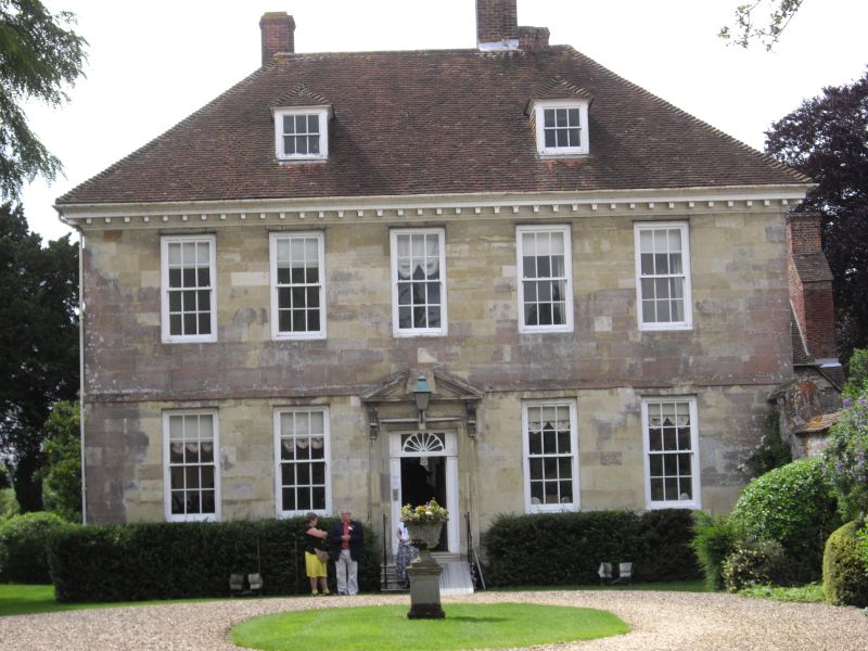
THE CLOSE
1.
1594
No 59 (Arundells)
SU 1429 NW 3/12 28.2.52.
II* GV
2.
Originally a canonical house largely rebuilt in late Cl7 by Sir Richard Mompesson.
Rain water head dated 1699, Set well back from the West Walk. East front:
2 storeys and attic. Ashlar stone with first floor string and plinth. Hipped
old tile roof with moulded and bracketed wood cornice. 2 hipped dormers with
small sashes. Symmetrical fenestration. 5 windows first floor, 4 on ground
floor, sashes, glazing bars restored in moulded frames. Central door of 6
fielded panels with stone architrave surround and moulded stone pediment on
console brackets. Similar 4 bay south front. The west front shows part of
earlier structure with gabled section with flintwork and hipped roof to wing.
Cl4 cusped headed 2 light window on first floor. Interior has full height
C18 panelling to drawing room. Early C18 stair with closed string, turned
balusters, square section panelled capped newels. Service stair with reset
C17 panelling as dado. The rear hipped roof wing has 2 trusses and wall posts.
All the listed buildings in the Close form an outstanding group.
Listing NGR: SU1411629644
External links are from the relevant listing authority and, where applicable, Wikidata. Wikidata IDs may be related buildings as well as this specific building. If you want to add or update a link, you will need to do so by editing the Wikidata entry.


Other nearby listed buildings
