Approximate Location Map
Large Map »
Latitude: 51.0769 / 51°4'36"N
Longitude: -1.8113 / 1°48'40"W
OS Eastings: 413313
OS Northings: 130855
OS Grid: SU133308
Mapcode National: GBR 516.JVG
Mapcode Global: FRA 7638.L4X
Plus Code: 9C3W35GQ+PF
Entry Name: Water Board Pumping Station
Listing Date: 12 October 1972
Grade: II
Source: Historic England
Source ID: 1355823
English Heritage Legacy ID: 319090
ID on this website: 101355823
Location: Churchfields, Wiltshire, SP2
County: Wiltshire
Civil Parish: Salisbury
Built-Up Area: Salisbury
Traditional County: Wiltshire
Lieutenancy Area (Ceremonial County): Wiltshire
Church of England Parish: Fisherton Anger St Paul
Church of England Diocese: Salisbury
Tagged with: Architectural structure
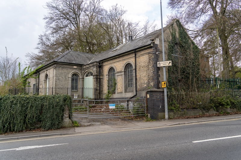
DEVIZES ROAD
1.
1594
Water Board Pumping Station
SU 1330 9/447
IT
2.
Circa 1850, 1 storey raised on plinth grey brick. L plan. Low pitch hipped
slate roof and gable end slate roof, flat eaves, Frieze with moulded bed.
South west front: left hand projecting part has recessed round headed window,
glazing bars, rendered pilaster frame and architrave over. Later window and
to right 6 panel door with radial glazed semi-circular fanlight, same surround +
as left hand window. Return front of projection has one similar window.
Recessed section has projecting entrance with large double doors, segmental
arched fanlight, plain rendered flanking strips, moulded imposts, architrave
over. Extension to right has 2 round headed windows with fixed iron glazing
bars with decorated ties. Plain rendered flanking strips, entablature linking
windows at impost level, architraves over. Gable end to street with stone
coping. Large round headed window with iron fixed glazing bars with rosette
pattern ties. Gault brick surround. Internally the pumping machinery is
modern.
Listing NGR: SU1331330855
External links are from the relevant listing authority and, where applicable, Wikidata. Wikidata IDs may be related buildings as well as this specific building. If you want to add or update a link, you will need to do so by editing the Wikidata entry.


Other nearby listed buildings
