Approximate Location Map
Large Map »
Latitude: 51.0708 / 51°4'14"N
Longitude: -1.8048 / 1°48'17"W
OS Eastings: 413774
OS Northings: 130180
OS Grid: SU137301
Mapcode National: GBR 517.SMG
Mapcode Global: FRA 7639.2QT
Plus Code: 9C3W35CW+83
Entry Name: Former GWR Station
Listing Date: 12 October 1972
Last Amended: 23 September 2008
Grade: II
Source: Historic England
Source ID: 1242134
English Heritage Legacy ID: 319148
ID on this website: 101242134
Location: St Paul's, Wiltshire, SP2
County: Wiltshire
Civil Parish: Salisbury
Built-Up Area: Salisbury
Traditional County: Wiltshire
Lieutenancy Area (Ceremonial County): Wiltshire
Church of England Parish: Fisherton Anger St Paul
Church of England Diocese: Salisbury
Tagged with: Architectural structure
676/9/479
FISHERTON STREET (South side),
FORMER GWR STATION
(Formerly listed as:
FISHERTON STREET
GOODS SHED OF SALISBURY STATION)
12-OCT-72
GV II
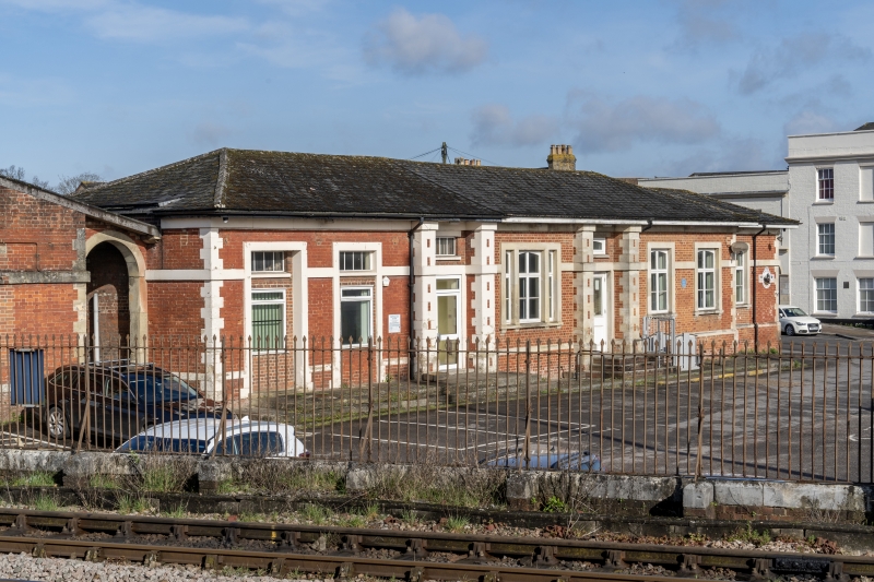
Former railway terminus. 1856 by Isambard Kingdom Brunel for the Great Western Railway. Constructed by Messrs. Hopkins and Roberts of Islington.
MATERIALS: Red brick with stone dressings, including quoins, plinth, string course and window surrounds. The windows are largely C20 and a mix of metal and uPVC frames. Slate and corrugated sheeting to roofs.
PLAN: L-shaped in plan with the principal entrance building with low pitched roof facing east onto Fisherton Street and, at right angles, a long range aligned west-east. Both are single storey.
EXTERIOR: The principal elevation faces west and is in a Late Classical style with a continuous string course and plinth, both of stone. The central section of seven bays is a symmetrical composition that breaks forward slightly. It has a central tripartite window, the lights divided by stone strips, and there are consoles to the sill. This window is flanked by a doorway to either side, both with full height rusticated stone piers and approached by shallow steps. The two outer windows to each side have stone surrounds carried through the plinth; those to the outer right hand bays have consoles to the sills. A canopy over the entrance was removed in the late C20. The central section is flanked by recessed bays to either side with similar dressings; that to the left contains a round-headed archway leading to the former platform. At right angles is the long range; its gable ends have been re-built and it appears that the roof has been raised slightly. Its south elevation comprises of ten square-headed windows that are largely blocked except for the upper parts. Attached to the west end is a brick-built structure that supports a water tank which is a mid- to late C20 addition. This building was lowered, and its roof removed to accommodate the water tank; both are unremarkable and not of interest. The north return of the range is fairly plain with some blockings and a number of inserted C20 entrances with double doors. A lean-to canopy supported on vertical steel I-beams has been added and is not of interest. The rear elevation of the entrance building is also largely devoid of features. To the rear (west) of the station building was a large train shed with wide span timber roof but this was demolished in 1970, although the platforms remain.
INTERIOR: Not inspected
HISTORY: Salisbury was slow to share in Britain's railway mania and it was not until 1847 when a branch line of the London and South Western Railway (LSWR) from Southampton brought rail traffic to the city. This line terminated at Milford on the eastern outskirts of the city. Within ten years, a new line had been constructed via Andover, also as part of the LSWR, and terminating at Milford. Between 1856 and 1859 further railway lines arrived in Salisbury. The first of these was laid in 1856 when the Wiltshire, Somerset and Weymouth, an off-shoot of the Great Western Railway completed a single track line from Warminster to Salisbury. The line used a broad gauge track and the trains terminated at a new station in Fisherton which was designed by the C19 engineer Isambard Kingdom Brunel. Facilities at the terminus included a four track layout with two platforms and an all-over roof in typical GWR style, an engine shed and a goods yard. In 1859 a second station was built, just to the south west of the Great Western terminus, by the Salisbury and Yeovil Railway Company; the London and South Western Railway also moved to this new station at Fisherton shortly after. A footbridge was erected to connect the GWR terminus with the adjacent LWSR (later the Southern Railway) station, but this was removed in 1956.
Following the extension of the Yeovil line to Exeter in 1860, and the conversion of the Warminster line from broad gauge to standard gauge in 1874; Salisbury now had the makings of an important railway junction, standing at the crossroads of two significant railway lines.
Brunel's terminus was closed to passenger traffic in 1932 when trains of the Southern Railway began using the adjacent former LSWR station. It was then used as a goods station, but since the mid-C20 the tracks have been removed and the buildings have alternative uses.
SOURCES: J. Chandler, Endless Street - A History of Salisbury and its People (1983), pp 139-43
G. Biddle and O.S. Nock, The Railway Heritage of Britain (1983), pp 208
http://www.british-history.ac.uk/report.aspx?compid=41809 A History of the County of Wiltshire, Fisherton Anger (1962), vol. 6, pp 180-94
REASON FOR DECISION:
The former GWR terminus at Fisherton is designated at Grade II for the following principal reasons:
* Designed by Isambard Kingdom Brunel, the eminent C19 engineer
* Despite alterations, it remains readable as a railway terminus of the mid-C19
* Its role in the historical development of this important railway junction
* Strong historical and visual group value with the adjacent Grade II listed Salisbury Railway Station
External links are from the relevant listing authority and, where applicable, Wikidata. Wikidata IDs may be related buildings as well as this specific building. If you want to add or update a link, you will need to do so by editing the Wikidata entry.


Other nearby listed buildings
