Approximate Location Map
Large Map »
Latitude: 51.0675 / 51°4'3"N
Longitude: -1.7973 / 1°47'50"W
OS Eastings: 414297
OS Northings: 129817
OS Grid: SU142298
Mapcode National: GBR 517.VTS
Mapcode Global: FRA 7639.KLS
Plus Code: 9C3W3693+23
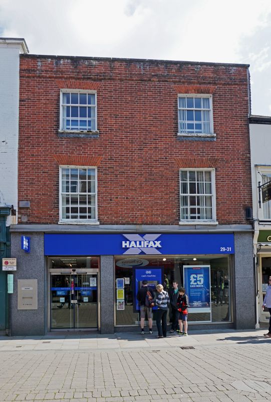
Entry Name: 29 and 31, High Street
Listing Date: 12 October 1972
Grade: II
Source: Historic England
Source ID: 1023690
English Heritage Legacy ID: 319184
ID on this website: 101023690
Location: Salisbury, Wiltshire, SP1
County: Wiltshire
Civil Parish: Salisbury
Built-Up Area: Salisbury
Traditional County: Wiltshire
Lieutenancy Area (Ceremonial County): Wiltshire
Church of England Parish: Salisbury St Thomas and St Edmund
Church of England Diocese: Salisbury
Tagged with: Building
HIGH STREET
1.
1594 (East Side)
Nos 29 & 31
SU 1429 NW 3/83A
II GV
2.
Late C18. 3 storeys red brick. Band cornice and parapet with stone coping.
2 windows to upper floors, recessed sashes, glazing bars intact, flat rubbed
arches. Modern shop front on ground floor.
Nos 25 to 31 (odd) form a group.
Listing NGR: SU1429729817
External links are from the relevant listing authority and, where applicable, Wikidata. Wikidata IDs may be related buildings as well as this specific building. If you want to add or update a link, you will need to do so by editing the Wikidata entry.


Other nearby listed buildings
