Approximate Location Map
Large Map »
Latitude: 51.0118 / 51°0'42"N
Longitude: -1.6506 / 1°39'2"W
OS Eastings: 424608
OS Northings: 123660
OS Grid: SU246236
Mapcode National: GBR 63J.HHY
Mapcode Global: FRA 76FF.W7R
Plus Code: 9C3W286X+PQ
Entry Name: Rabbit Cottage
Listing Date: 4 July 1985
Grade: II
Source: Historic England
Source ID: 1300189
English Heritage Legacy ID: 319763
ID on this website: 101300189
Location: Whiteparish, Wiltshire, SP5
County: Wiltshire
Civil Parish: Whiteparish
Built-Up Area: Whiteparish
Traditional County: Wiltshire
Lieutenancy Area (Ceremonial County): Wiltshire
Church of England Parish: Whiteparish All Saints
Church of England Diocese: Salisbury
Tagged with: Cottage
WHITEPARISH DEAN LANE
SU 22 SW
(west side)
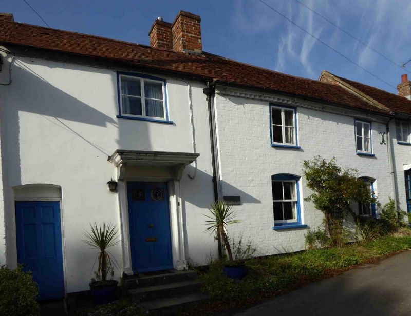
7/291 Rabbit Cottage
GV II
Cottage in row. Late C18. Painted Flemish bond brick, tiled roof,
brick stack. 2-storey, 3-window. 6-panelled door with flat wooden
hood on brackets, to left is 6-panelled door to entry, to right are
two 4-pane sashes. First floor has three 2-light casements.
Interior not inspected.
Listing NGR: SU2460823660
External links are from the relevant listing authority and, where applicable, Wikidata. Wikidata IDs may be related buildings as well as this specific building. If you want to add or update a link, you will need to do so by editing the Wikidata entry.


Other nearby listed buildings
