Approximate Location Map
Large Map »
Latitude: 51.0848 / 51°5'5"N
Longitude: -1.9883 / 1°59'18"W
OS Eastings: 400912
OS Northings: 131723
OS Grid: SU009317
Mapcode National: GBR 2Y4.VGZ
Mapcode Global: FRA 66Q8.35S
Plus Code: 9C3W32M6+WM
Entry Name: Old Schoolroom
Listing Date: 17 December 1986
Grade: II
Source: Historic England
Source ID: 1318761
English Heritage Legacy ID: 320751
ID on this website: 101318761
Location: Dinton, Wiltshire, SP3
County: Wiltshire
Civil Parish: Dinton
Built-Up Area: Dinton
Traditional County: Wiltshire
Lieutenancy Area (Ceremonial County): Wiltshire
Church of England Parish: Dinton St Mary
Church of England Diocese: Salisbury
Tagged with: School building Thatched building
SU 03 SW
1/165
DINTON
ST MARYS ROAD
(west side)
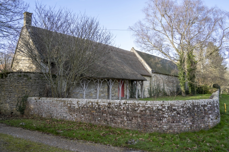
Old School room
GV
II
School room, now part of Hydes House outbuildings. C17, altered
early C19. Rubble stone, thatched roof with coped verge and ashlar
stack with moulded capping to left. Rustic verandah under thatched
roof to front; ledged and studded door to right. Rear has two 3-
light leaded casements.
Listing NGR: SU0091231723
External links are from the relevant listing authority and, where applicable, Wikidata. Wikidata IDs may be related buildings as well as this specific building. If you want to add or update a link, you will need to do so by editing the Wikidata entry.


Other nearby listed buildings
