Approximate Location Map
Large Map »
Latitude: 51.0743 / 51°4'27"N
Longitude: -2.1708 / 2°10'15"W
OS Eastings: 388126
OS Northings: 130570
OS Grid: ST881305
Mapcode National: GBR 1WR.HZN
Mapcode Global: FRA 66B8.XRS
Plus Code: 9C3V3RFH+PM
Entry Name: Lindley Cottage
Listing Date: 9 September 1987
Grade: II
Source: Historic England
Source ID: 1198233
English Heritage Legacy ID: 321163
ID on this website: 101198233
Location: East Knoyle, Wiltshire, SP3
County: Wiltshire
Civil Parish: East Knoyle
Built-Up Area: East Knoyle
Traditional County: Wiltshire
Lieutenancy Area (Ceremonial County): Wiltshire
Church of England Parish: East Knoyle St Mary
Church of England Diocese: Salisbury
Tagged with: Cottage
EAST KNOYLE THE STREET
ST 83 SE
(west side)
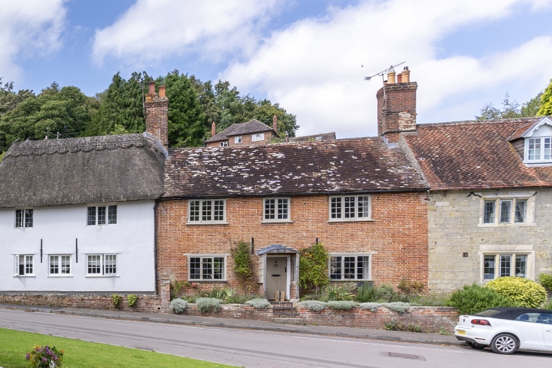
8/57 No 14 (Lindley Cottage)
GV II
Cottage in row. Circa 1700. Flemish bond brick, tiled roof with
gable end brick stacks. Two-storey, 3-window. Central planked
door in segmental-headed porch, 3-light leaded casement either
side. First floor has 2-light wooden casement over door with 3-
light either side. Rear wall rubble stone.
Listing NGR: ST8812630570
External links are from the relevant listing authority and, where applicable, Wikidata. Wikidata IDs may be related buildings as well as this specific building. If you want to add or update a link, you will need to do so by editing the Wikidata entry.


Other nearby listed buildings
