Approximate Location Map
Large Map »
Latitude: 54.2834 / 54°17'0"N
Longitude: -1.8091 / 1°48'32"W
OS Eastings: 412527
OS Northings: 487550
OS Grid: SE125875
Mapcode National: GBR HLTX.48
Mapcode Global: WHC6Y.5LSL
Plus Code: 9C6W75MR+99
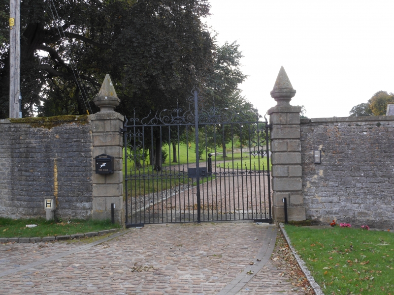
Entry Name: Hall Gate-Piers
Listing Date: 25 June 1985
Grade: II
Source: Historic England
Source ID: 1130911
English Heritage Legacy ID: 321705
ID on this website: 101130911
Location: West End, North Yorkshire, DL8
County: North Yorkshire
District: Richmondshire
Civil Parish: Middleham
Built-Up Area: Middleham
Traditional County: Yorkshire
Lieutenancy Area (Ceremonial County): North Yorkshire
Tagged with: Architectural structure
SE 18 NW MIDDLEHAM WEST END
(west side)
9/77 Hall gate-piers
GV II
Gate-piers. Early C19. Ashlar sandstone. Rusticated gate-piers
approximately 2 metres high on plain plinths with plain cornices and conical
caps on urn bases.
Listing NGR: SE1252587553
External links are from the relevant listing authority and, where applicable, Wikidata. Wikidata IDs may be related buildings as well as this specific building. If you want to add or update a link, you will need to do so by editing the Wikidata entry.


Other nearby listed buildings
