Approximate Location Map
Large Map »
Latitude: 54.3893 / 54°23'21"N
Longitude: -1.6515 / 1°39'5"W
OS Eastings: 422730
OS Northings: 499369
OS Grid: SE227993
Mapcode National: GBR JKXP.8B
Mapcode Global: WHC6F.LXSZ
Plus Code: 9C6W98QX+PC
Entry Name: Catterick Bridge
Listing Date: 4 February 1969
Last Amended: 6 November 1986
Grade: II*
Source: Historic England
Source ID: 1317092
English Heritage Legacy ID: 322065
ID on this website: 101317092
Location: Catterick Bridge, North Yorkshire, DL10
County: North Yorkshire
District: Richmondshire
Civil Parish: Brough with St. Giles
Traditional County: Yorkshire
Lieutenancy Area (Ceremonial County): North Yorkshire
Church of England Parish: Catterick St Anne
Church of England Diocese: Leeds
BROMPTON-ON-SWALE A 6136
SE 29 NW
8/2 Catterick Bridge
4/2/69 (Formerly listed in the
Parish of Brough)
GV II*
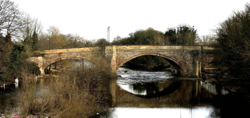
Bridge. 1422, probably rebuilt 1565-90, much repaired C17, widened 1792.
Older bridge for William de Burgh of Brough Hall, widening by John Carr of
York. Sandstone ashlar. 4 arches separated by triangular cutwaters with
hollow-chamfered tops sweeping up to canted pedestrian retreats. Band.
Parapets with triangular coping terminating in circular bollards, the
downstream parapet curving outwards in plan. Older bridge on upstream side:
central 2 arches of 2 slightly-pointed chamfered orders, outer arches
semicircular and faced with C18 stonework. Undersides of earlier arches
bear masons' marks. The Carr bridge on downstream side: 3 semicircular
arches and 1 segmental arch, with torus archivolts. Small barrel-vaulted
chamber in spandrel adjacent to southernmost arch on downstream side. The
contract for building the bridge survives in the County Record Office.
There was a chantry chapel, dedicated to St Anne, founded in 1505, on the
south-east side of the medieval bridge. Part of downstream parapet
dismantled at time of resurvey. Scheduled as an Ancient Monument. Partly
in the parish of Brough with St Giles. E Jervoise, Ancient Bridges of The
North of England, (1931), p 87; York Georgian Society, The Works in.
Architecture of John Carr (1973), p 6; VCH i, p 301.
Listing NGR: SE2273099369
External links are from the relevant listing authority and, where applicable, Wikidata. Wikidata IDs may be related buildings as well as this specific building. If you want to add or update a link, you will need to do so by editing the Wikidata entry.


Other nearby listed buildings
