Approximate Location Map
Large Map »
Latitude: 54.3982 / 54°23'53"N
Longitude: -1.718 / 1°43'4"W
OS Eastings: 418404
OS Northings: 500338
OS Grid: NZ184003
Mapcode National: GBR JKFL.V4
Mapcode Global: WHC6D.LQ34
Plus Code: 9C6W97XJ+7Q
Entry Name: Abbey Mill
Listing Date: 6 November 1986
Grade: II
Source: Historic England
Source ID: 1317098
English Heritage Legacy ID: 322104
ID on this website: 101317098
Location: Easby, North Yorkshire, DL10
County: North Yorkshire
District: Richmondshire
Civil Parish: Easby
Traditional County: Yorkshire
Lieutenancy Area (Ceremonial County): North Yorkshire
Church of England Parish: Easby with Brompton on Swale and Bolton on Swale
Church of England Diocese: Leeds
Tagged with: Mill
EASBY EASBY
NZ 10 SE
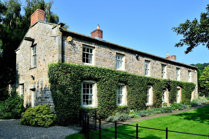
4/38 Abbey Mill
GV II
Marked on Ordnance Survey Map as Abbey Farm. Corn watermill and mill-house,
now house. Late C18 - early C19, on much older foundations. Coursed
rubble, stone slate roof. 2 storeys, 6 bays. Quoins. In fourth bay, part-
glazed C20 6-panel door below plain fanlight in ashlar surround on plinths,
with imposts, voussoirs to semicircular arch and tripartite keystone.
Ground-floor windows: sashes with glazing bars in ashlar surrounds, those of
first to third bays C20 copies. First floor: windows with flat arches,
those in first and second bays 9-pane unequally-hung sashes, the rest sashes
with glazing bars. Shaped kneelers, ashlar copings. Brick stacks at ends
and between second and third bays. The corn watermill formerly occupied the
first 3 bays, and had a matching doorway in the third bay. Below the second
ground-floor window is a blocked small square surround to a window which
lighted the gearing. The mill originally served the Abbey (qv) and was
connected with the river Swale by the head race and tail race; the ashlar-
lined wheelchamber being below the first bay. The watermill operated into
the 1950s, latterly generating electricity for the hamlet of Easby with a
turbine which is still in position in the wheelchamber, until it was
replaced by the National Grid.
Listing NGR: NZ1865900309
External links are from the relevant listing authority and, where applicable, Wikidata. Wikidata IDs may be related buildings as well as this specific building. If you want to add or update a link, you will need to do so by editing the Wikidata entry.


Other nearby listed buildings
