Approximate Location Map
Large Map »
Latitude: 54.1197 / 54°7'10"N
Longitude: -2.5321 / 2°31'55"W
OS Eastings: 365316
OS Northings: 469443
OS Grid: SD653694
Mapcode National: GBR BNRS.LZ
Mapcode Global: WH953.2QH4
Plus Code: 9C6V4F99+V5
Entry Name: Plague Stone
Listing Date: 24 June 1988
Grade: II
Source: Historic England
Source ID: 1157461
English Heritage Legacy ID: 324058
ID on this website: 101157461
Location: Low Bentham, North Yorkshire, LA2
County: North Yorkshire
District: Craven
Civil Parish: Bentham
Built-Up Area: Low Bentham
Traditional County: Yorkshire
Lieutenancy Area (Ceremonial County): North Yorkshire
Church of England Parish: Bentham
Church of England Diocese: Leeds
Tagged with: Architectural structure
SD 66 NE
6/7
BENTHAM
BENTHAM ROAD (north side)
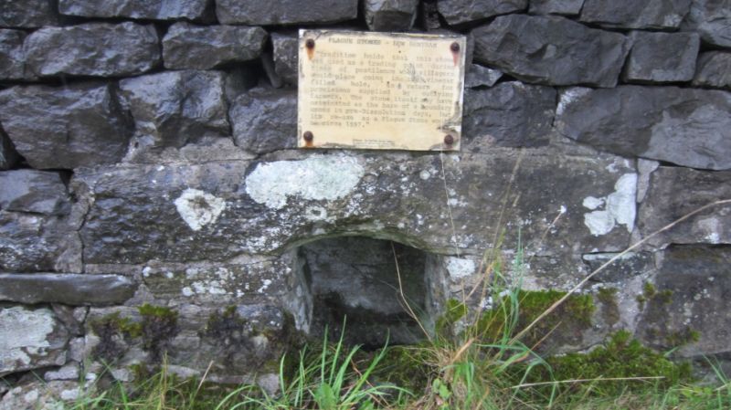
Plague Stone
II
Small basin, reputed to mark extent of quarantine during the plague. C17. Stone. Basin about 15cm square, recessed into wall. Curved with segmental-headed lintel to form opening about 20cm square.
Listing NGR: SD6531669443
External links are from the relevant listing authority and, where applicable, Wikidata. Wikidata IDs may be related buildings as well as this specific building. If you want to add or update a link, you will need to do so by editing the Wikidata entry.


Other nearby listed buildings
