Approximate Location Map
Large Map »
Latitude: 54.1435 / 54°8'36"N
Longitude: -2.1051 / 2°6'18"W
OS Eastings: 393230
OS Northings: 471969
OS Grid: SD932719
Mapcode National: GBR FNRJ.1F
Mapcode Global: WHB6F.M3SV
Plus Code: 9C6V4VVV+CX
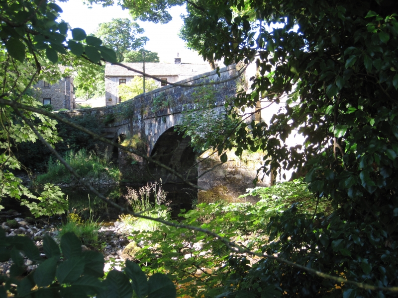
Entry Name: Arncliffe Bridge over River Skirfare
Listing Date: 20 February 1958
Grade: II
Source: Historic England
Source ID: 1316768
English Heritage Legacy ID: 324589
ID on this website: 101316768
Location: Arncliffe, North Yorkshire, BD23
County: North Yorkshire
District: Craven
Civil Parish: Arncliffe
Traditional County: Yorkshire
Lieutenancy Area (Ceremonial County): North Yorkshire
Tagged with: Bridge
SD 9271 - 9371 ARNCLIFFE GOOSELANDS HILL ROAD
22/4 Arncliffe Bridge over
20.2.58 River Skirfare
GV II
Bridge. Mid-late C18. Ashlar. 3 segmental arches with 2 pointed
cutwaters rising as pilasters to parapet level. Projecting band at road
level and slightly gabled projecting parapet coping.
Listing NGR: SD9323071969
External links are from the relevant listing authority and, where applicable, Wikidata. Wikidata IDs may be related buildings as well as this specific building. If you want to add or update a link, you will need to do so by editing the Wikidata entry.


Other nearby listed buildings
