Approximate Location Map
Large Map »
Latitude: 54.1417 / 54°8'30"N
Longitude: -2.1053 / 2°6'18"W
OS Eastings: 393220
OS Northings: 471769
OS Grid: SD932717
Mapcode National: GBR FNRK.02
Mapcode Global: WHB6F.M5P7
Plus Code: 9C6V4VRV+MV
Entry Name: Elm House
Listing Date: 20 February 1958
Grade: II
Source: Historic England
Source ID: 1316792
English Heritage Legacy ID: 324605
ID on this website: 101316792
Location: Arncliffe, North Yorkshire, BD23
County: North Yorkshire
District: Craven
Civil Parish: Arncliffe
Traditional County: Yorkshire
Lieutenancy Area (Ceremonial County): North Yorkshire
Tagged with: House
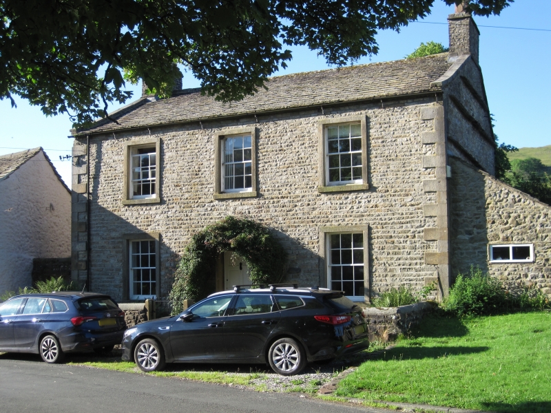
SD 9271 - 9371 ARNCLIFFE VILLAGE GREEN
(south side)
22/18 Elm House
20.2.58
GV II
House. Early C19. Coursed rubble, ashlar dressings, graduated stone slate
roof. 2 storeys, 3 bays. Raised quoins. Central 6-panel door in plain stone
surround with pitched slab hood on stone brackets. Sashes with glazing
bars in slightly projecting surrounds. Gable copings; end stacks.
Interior not inspected at re-survey. Outshut to right not of special
interest.
Listing NGR: SD9322071769
External links are from the relevant listing authority and, where applicable, Wikidata. Wikidata IDs may be related buildings as well as this specific building. If you want to add or update a link, you will need to do so by editing the Wikidata entry.


Other nearby listed buildings
