Approximate Location Map
Large Map »
Latitude: 54.1462 / 54°8'46"N
Longitude: -2.0467 / 2°2'47"W
OS Eastings: 397049
OS Northings: 472263
OS Grid: SD970722
Mapcode National: GBR GN4H.PG
Mapcode Global: WHB6G.J1MS
Plus Code: 9C6V4XW3+F8
Entry Name: The Green
Listing Date: 10 September 1954
Last Amended: 4 May 1989
Grade: II
Source: Historic England
Source ID: 1173607
English Heritage Legacy ID: 324686
ID on this website: 101173607
Location: Kettlewell, North Yorkshire, BD23
County: North Yorkshire
District: Craven
Civil Parish: Kettlewell with Starbotton
Traditional County: Yorkshire
Lieutenancy Area (Ceremonial County): North Yorkshire
Tagged with: Architectural structure
SD 9672-9772 KETTLEWELL WITH STARBOTTON THE GREEN
(south side)
Kettlewell
21/100 The Green (sic)
(formerly listed as cottage
10.9.54 west of Manor Cottage)
GV II
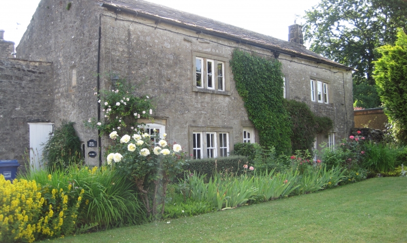
House. Mid C17 with early C18 alterations and C20 restoration. Coursed
limestone rubble, gritstone dressings, graduated stone slate roof. 2
storeys, 3 bays. Former door, now window to far left, with shallow pointed
arch having "H H" in relief in right spandrel and a recessed panel with
date not legible at time of resurvey. C20 glazed doors to left of bays 2
and 3 in plain surrounds. Random fenestration; 3-light flat-faced
mullioned windows in moulded architraves to ground and first-floor, left,
narrow window with reused stone surrounds to right of central door, ground
and first floor, and far right; 3-light window with recessed and chamfered
surround and flat-faced mullions to far right, first-floor. Large corniced
stack to left gable; a smaller stack far right. Rear: a 2-light mullioned
window to ground and first floor, left. Left return: a narrow round-headed
window to ground floor, right; a blocked rectangular window above. The
date is recorded as 1657 and the left-hand spandrel had the initials, "I
T". The extensive alterations and 2 inserted doorways suggest that this
property was one of those converted to three cottages for lead miners in
the C18.
Listing NGR: SD9704972263
External links are from the relevant listing authority and, where applicable, Wikidata. Wikidata IDs may be related buildings as well as this specific building. If you want to add or update a link, you will need to do so by editing the Wikidata entry.


Other nearby listed buildings
