Approximate Location Map
Large Map »
Latitude: 54.1772 / 54°10'37"N
Longitude: -1.768 / 1°46'4"W
OS Eastings: 415242
OS Northings: 475735
OS Grid: SE152757
Mapcode National: GBR JN34.1C
Mapcode Global: WHC7J.T89J
Plus Code: 9C6W56GJ+VR
Entry Name: Arnagill Tower
Listing Date: 28 April 1986
Grade: II
Source: Historic England
Source ID: 1132034
English Heritage Legacy ID: 325022
ID on this website: 101132034
Location: North Yorkshire, HG4
County: North Yorkshire
District: Harrogate
Civil Parish: Ilton-cum-Pott
Traditional County: Yorkshire
Lieutenancy Area (Ceremonial County): North Yorkshire
Tagged with: Tower
SE 17 NE ILTON-CUM-POTT
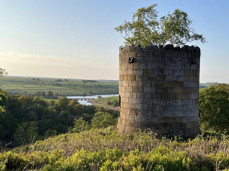
5/32 Arnagill Tower
- II
Folly. 1824 by John Foss. Rubblestone, roof material not known. Round in
plan. 1 storey with arched door opening and 3 arched window openings. Plan
and elevation by John Foss in possession of S Cunliffe-Lister, Glebe House,
Masham.
Listing NGR: SE1524275735
External links are from the relevant listing authority and, where applicable, Wikidata. Wikidata IDs may be related buildings as well as this specific building. If you want to add or update a link, you will need to do so by editing the Wikidata entry.


Other nearby listed buildings
