Approximate Location Map
Large Map »
Latitude: 53.7841 / 53°47'2"N
Longitude: -1.0695 / 1°4'10"W
OS Eastings: 461407
OS Northings: 432381
OS Grid: SE614323
Mapcode National: GBR NSZP.77
Mapcode Global: WHFD2.J4YV
Plus Code: 9C5WQWMJ+M6
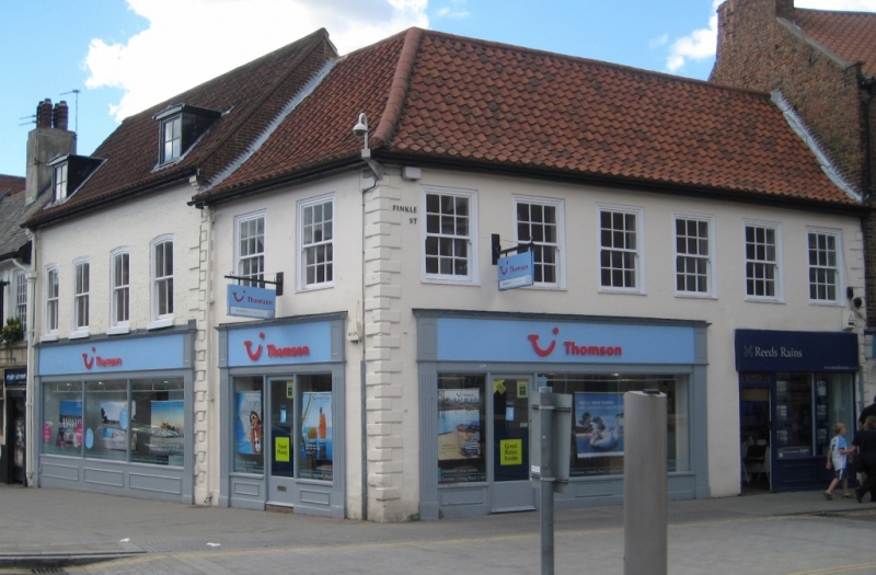
Entry Name: 1, Finkle Street
Listing Date: 11 December 1968
Grade: II
Source: Historic England
Source ID: 1316634
English Heritage Legacy ID: 325727
ID on this website: 101316634
Location: Selby, North Yorkshire, YO8
County: North Yorkshire
District: Selby
Civil Parish: Selby
Built-Up Area: Selby
Traditional County: Yorkshire
Lieutenancy Area (Ceremonial County): North Yorkshire
Church of England Parish: Selby St Mary and St Germain
Church of England Diocese: York
Tagged with: Building
FINKLE STREET
1. (west side)
5342 -------------
No 1
SE 6132 SW 4/5 11.12.68
II GV
2.
C18. Stucco. Hipped and sprocketed pantile roof. Two storeys. Rusticated quoins.
Six bays to Finkle Street, 2 to Gowthorpe: cased sashes with glazing bars. Modern
shop-fronts.
Listing NGR: SE6140732381
External links are from the relevant listing authority and, where applicable, Wikidata. Wikidata IDs may be related buildings as well as this specific building. If you want to add or update a link, you will need to do so by editing the Wikidata entry.


Other nearby listed buildings
