Approximate Location Map
Large Map »
Latitude: 53.7841 / 53°47'2"N
Longitude: -1.0696 / 1°4'10"W
OS Eastings: 461403
OS Northings: 432372
OS Grid: SE614323
Mapcode National: GBR NSZP.78
Mapcode Global: WHFD2.J4XX
Plus Code: 9C5WQWMJ+J5
Entry Name: 2, Gowthorpe
Listing Date: 14 November 1980
Grade: II
Source: Historic England
Source ID: 1132577
English Heritage Legacy ID: 325757
ID on this website: 101132577
Location: Selby, North Yorkshire, YO8
County: North Yorkshire
District: Selby
Civil Parish: Selby
Built-Up Area: Selby
Traditional County: Yorkshire
Lieutenancy Area (Ceremonial County): North Yorkshire
Church of England Parish: Selby St Mary and St Germain
Church of England Diocese: York
Tagged with: Building
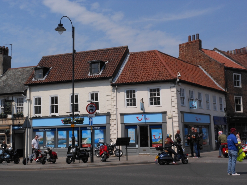
GOWTHORPE
1. (north side)
5342 ------------
No 2
SE 6132 SW 4/26
II GV
2.
Mid C18, extended upwards and re-roofed in mid or late C19. Colour-washed brick.
Pitched modern pantile roof. Two storeys and attics. Alternate raised quoins
except for C19 part. Four bays: narrow segment-headed flush-framed sashes. Two
flat-topped attic dormers. Modern shop-front.
Listing NGR: SE6140332372
External links are from the relevant listing authority and, where applicable, Wikidata. Wikidata IDs may be related buildings as well as this specific building. If you want to add or update a link, you will need to do so by editing the Wikidata entry.


Other nearby listed buildings
