Approximate Location Map
Large Map »
Latitude: 53.7829 / 53°46'58"N
Longitude: -1.0752 / 1°4'30"W
OS Eastings: 461034
OS Northings: 432233
OS Grid: SE610322
Mapcode National: GBR NSYP.0P
Mapcode Global: WHFD2.G57T
Plus Code: 9C5WQWMF+4W
Entry Name: 106, Gowthorpe
Listing Date: 14 November 1980
Grade: II
Source: Historic England
Source ID: 1316644
English Heritage Legacy ID: 325772
ID on this website: 101316644
Location: Westfield, North Yorkshire, YO8
County: North Yorkshire
District: Selby
Civil Parish: Selby
Built-Up Area: Selby
Traditional County: Yorkshire
Lieutenancy Area (Ceremonial County): North Yorkshire
Church of England Parish: Selby St James
Church of England Diocese: York
Tagged with: Building
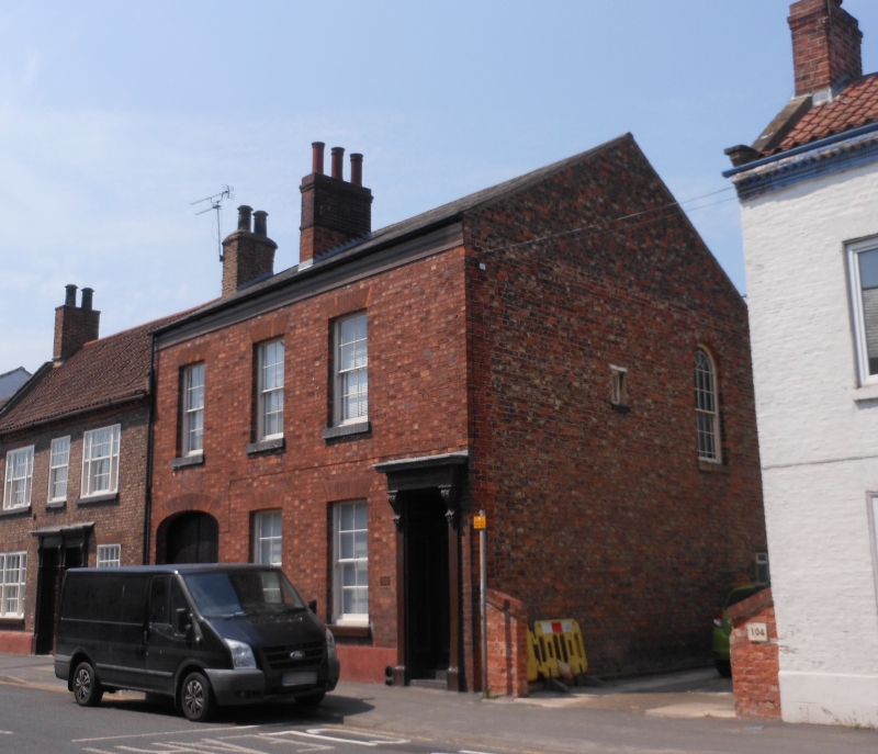
GOWTHORPE
1. (north side)
5342 ------------
No 106
SE 6132 SW 4/84
II GV
2.
Mid C19. Red brick. Pitched slate roof. Two storeys. Three bays: sashes
with glazing bars. Door with 2 moulded panels and oblong fanlight in
panelled reveals: wooden frame with moulded consoles to entablature.
Carriage entrance with 3-centred arched head with finely gauged brick
voussoirs.
Listing NGR: SE6103432232
External links are from the relevant listing authority and, where applicable, Wikidata. Wikidata IDs may be related buildings as well as this specific building. If you want to add or update a link, you will need to do so by editing the Wikidata entry.


Other nearby listed buildings
