Approximate Location Map
Large Map »
Latitude: 53.7849 / 53°47'5"N
Longitude: -1.0657 / 1°3'56"W
OS Eastings: 461655
OS Northings: 432470
OS Grid: SE616324
Mapcode National: GBR PS0N.2Y
Mapcode Global: WHFD2.L4Q7
Plus Code: 9C5WQWMM+XP
Entry Name: 38, Ousegate
Listing Date: 14 November 1980
Grade: II
Source: Historic England
Source ID: 1365819
English Heritage Legacy ID: 325816
ID on this website: 101365819
Location: Selby, North Yorkshire, YO8
County: North Yorkshire
District: Selby
Civil Parish: Selby
Built-Up Area: Selby
Traditional County: Yorkshire
Lieutenancy Area (Ceremonial County): North Yorkshire
Church of England Parish: Selby St Mary and St Germain
Church of England Diocese: York
Tagged with: Building
This list entry was subject to a Minor Enhancement on 16 June 2022 to amend the description and to reformat the text to current standards.
SE 6132 SE
5/124
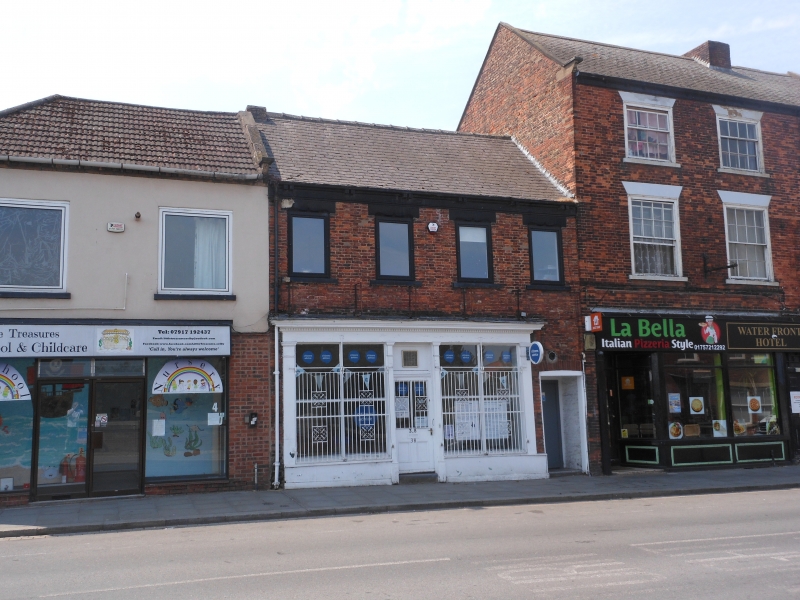
OUSEGATE
No 38
GV
II
Mid C19. Red brick. Pitched slate roof. Two storeys. Paired brackets to eaves. Four first-floor windows with moulded lintels. Shop-front with Tuscan pilasters and entablature with dentilled cornice.
The name Ousegate may have a Viking origin, as the suffix ‘gate’ is derived from the old Norse word ‘gatta’ meaning street. Ousegate is the historic riverfront street of Selby and remained an important area of commercial activity, after the opening of the Selby Canal in 1778, and the completion of the Selby Toll Bridge in 1792. A map dating to 1848 shows that the former burgage plot to the rear of 38 Ousegate was once totally built over by a terrace of three properties, a small enclosed yard, and a rectangular garden, all accessed by a passageway to one side of the shop. With minor changes this arrangement remained until about 1980, when most of these buildings were demolished and the garden became part of the car park serving the Church Lane/Gant Walk housing development.
Listing NGR: SE6165532470
External links are from the relevant listing authority and, where applicable, Wikidata. Wikidata IDs may be related buildings as well as this specific building. If you want to add or update a link, you will need to do so by editing the Wikidata entry.


Other nearby listed buildings
