Approximate Location Map
Large Map »
Latitude: 53.7857 / 53°47'8"N
Longitude: -1.0667 / 1°4'0"W
OS Eastings: 461589
OS Northings: 432555
OS Grid: SE615325
Mapcode National: GBR NSZN.VP
Mapcode Global: WHFD2.L38N
Plus Code: 9C5WQWPM+78
Entry Name: Abbots Staith Buildings
Listing Date: 16 December 1952
Last Amended: 14 November 1980
Grade: II*
Source: Historic England
Source ID: 1167663
English Heritage Legacy ID: 325850
Also known as: The Abbot's Staithes
Abbot's Staith
ID on this website: 101167663
Location: Selby, North Yorkshire, YO8
County: North Yorkshire
District: Selby
Civil Parish: Selby
Built-Up Area: Selby
Traditional County: Yorkshire
Lieutenancy Area (Ceremonial County): North Yorkshire
Church of England Parish: Selby St Mary and St Germain
Church of England Diocese: York
Tagged with: Building
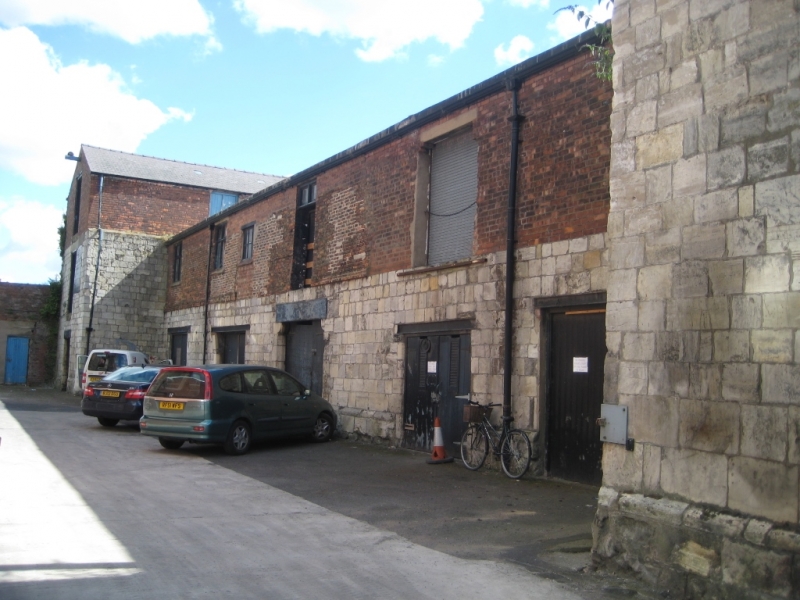
WATER LANE
1. ----------
5342 Abbot's Staith Buildings
(formely listed under
SE 6132 NE 2/10 16.12.52 The Quay)
II*
2.
C15 or early C16. Magnesian limestone ashlar. Two storeys. H-shaped plan, with
a long centre arm; but this plan is obscured on the Micklegate side, by the addition
in the C19 of the buildings now occupied by the office and shop of Woodheads Seeds
Limited, and by the Pendulum Club. On the Micklegate (south) side the upper storey
of the east wing was rebuilt in red brick in the C19, and the upper storey of the west
wing is missing. On the north side the first floor of the central arm may perhaps
have been timber-framed, as it has been refaced in red brick above a red brick band
in the late C17 or early C18 (although this brick has been patched subsequently):
Chamfered plinth. The dating evidence comes from the first floor windows on the
south side, which have deep double-chamfered embrasures. One in the east wing
is visible from the street. Another, with a hood-mould and an inserted lintel,
the easternmost of those in the centre arm, is only partly obscured by the buildings
added along the Micklegate side. There are three more only visible from behind
these buildings. Other windows are modern.
On the north side there are two doors which may be contemporary. One in the centre
has a shouldered lintel, and the other is in the east wing. Both are studded and
have contemporary iron hinges and latches.
Internally there are thick limestone diaphragm walls at regular intervals.
History: Traditionally supposed to have been built by the Abbey, the architectural
evidence tends to support this. In use as warehousing certainly from the C17,
and probably always, it is presumably the building described by Pocock in list
thus: "Near the river is a large store house of hewn stone, which served for their
cloth before the Aire was made navigable". The latter took place in 1704. A.M.
Listing NGR: SE6158932555
External links are from the relevant listing authority and, where applicable, Wikidata. Wikidata IDs may be related buildings as well as this specific building. If you want to add or update a link, you will need to do so by editing the Wikidata entry.


Other nearby listed buildings
